
|
Sarah Rothwell
The Traditions of the Sun web site project is a collaboration between NASA's Sun-Earth Connection Education Forum, the National Park Service at Chaco Canyon, INAH and UNAM in Mexico, and Ideum, a multimedia design firm located in Sausalito, CA. The web site illustrates archaeoastronomy at two important archaeological regions in the Americas: the Chaco Canyon area and the Yucatan. Through a series of still photographs, time-lapse movies and QuickTime VR panoramas, the web site presents the archaeoastronomy (with particular relation to the sun), architecture and natural environment of these regions.
This web site was nominated for a Webby(c) Award in categories of Science and Education in 2005. The site initially illustrated just the Chaco Canyon region, but on June 22, 2005 (timed to coincide, more or less, with the summer solstice, of course) the Yucatan portion of the project was added.
This web site is, for the most part, a multi-faceted interactive Flash application, and in order to review it I have examined aspects of information, navigation and design.
The site is clearly aimed at the general public and this is nowhere more evident than in the text provided in both the Yucatan and Chaco portions of the site. Text passages associated with the extensive image galleries, QuickTime VR panoramas and time-lapse movies are generally short and, while clear and succinct, do not go into the kind of detail that would satisfy the student or professional. This is no real surprise since the main writing and research credits go to staff members for Ideum, the multimedia design company that designed the site. Most of the professional archaeologists and astronomers from the partner institutions are only credited with "additional" material; however, professionals are also given production and advisory credits suggesting that the information has been checked for accuracy, and I noted no obvious errors.
However, the casual student can learn a lot from, and certainly be captivated by, the visual material presented. First, I enjoyed the use of aerial photographs containing links to the various ground-based and additional aerial photographs, QuickTime VR panoramas and time-lapse movies. I could turn the various types of links on and off, reducing clutter and making the result more useful. I liked the fact that I could zoom in or out on the main aerial photographs and even pan, but also had a navigation panel immediately below the photograph to keep track of my location.
Second, the images and movies themselves were generally interesting and informative. Many of the images can either be viewed along the left side of the screen or expanded to a full-screen format. Images include not just recent images taken for this project but also the occasional historic image. When loaded, the QuickTime VR panorama pages initially only display a still image. The user then has the option whether or not to play the QuickTime. This avoids problems that users might have if they do not have QuickTime installed. Links to the QuickTime installation site are provided on the home page and on the help page.
Another comment on the QuickTime VR panoramas: while I like the zoom feature, when the user zooms in too far the image becomes pixilated and when the user zooms out to the maximum, the image distorts. The distortion is due to the use of a very-wide-angle lens for the original image (Eiteljorg, personal communication). Neither the pixilation nor the distortion is completely unexpected, but it might have been better to limit the extent of the zoom.
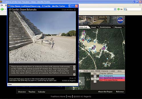
Figure 1. Screen shot showing QuickTime VR panorama pop-up window with web page in the background.
Some of the Chacoan ground-based photographs actually feature QuickTime VR composites of historic and current images to show, for example, the results of stabilization projects. I found these fascinating but they are hidden among all the other still image links. A pleasant little surprise, perhaps, for those willing to put in the time looking.
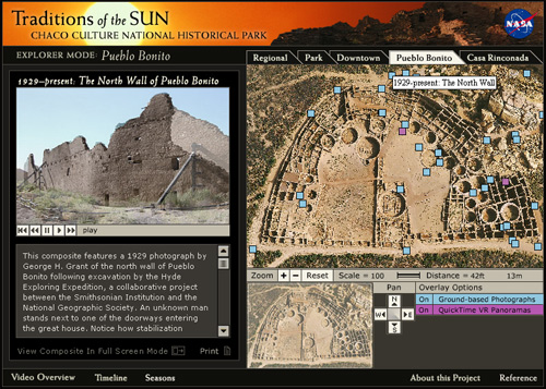
Figure 2. One of the Chaco composite images, showing the north wall of Pueblo Bonito, 1929 - present.
The best thing about the way the images are presented is that by using the combination of aerial photographs and the various links the user gets a real feel for how space and the various features of the sites tie together. This feeling is further enhanced by the addition of GPS co-ordinates for many of the linked items in the text.
One of the most satisfying aspects of this site is the navigation. The design is consistent and easy to understand. There are also multiple ways to access particular pieces of information.
From the home page the user can move to the two separate modules: Chaco Culture National Historic Park or the Yucatan. Navigation around each of these modules is organized similarly; the right half of the screen shows an aerial photograph with a series of hotspots. The hot spots are colour-coded and a key below the aerial photograph shows which hotspots provide the user with additional photographs, Time-lapse Movies, Map Jumps etc. The Map Jumps take the user to different sub-sections of the modules. Each sub-section is represented by an aerial photograph with its own set of links. In the case of the Chaco Canyon module, the user is offered the option of jumping to "Regional", "Park", "Downtown", "Pueblo Bonito" or "Casa Rinconada" sub-sections. Since not all of these sub-sections have map jumps to each other (for instance, the user cannot jump from "Pueblo Bonito" to "Regional") these sub-sections can also be accessed through a series of tabs along the top of the aerial photographs.
Information accessed generally opens up on the left half of the screen, with the aerial photograph remaining visible on the right half. There is a further option to view the images and information on the left side of the screen in a full screen mode. When the images are opened in the full screen mode links to related materials within the module are also provided to the side of the image.
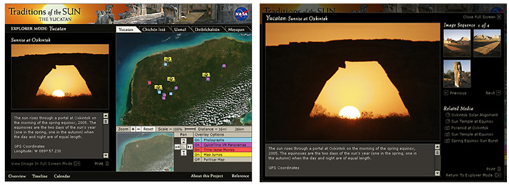
Figure 3. Screen shot showing normal screen on the left and "Full Screen mode" on the right.
A secondary navigation bar is at the base of the main pages. This links to further information concerning each module, covering topics such as Timeline and Overview. I had a fair bit of fun with the Calendar section in the Yucatan module.
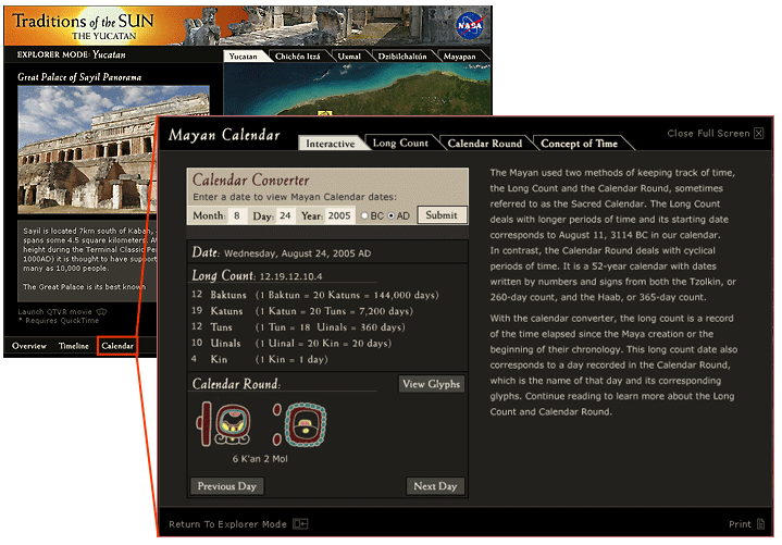
Figure 4. Mayan calendar information and how to find it.
As with the navigation, the visual design is consistent and well considered. Colours have been chosen carefully to provide good contrast between the background and image or text. Once the user is past the home page and into the modules, pages are set up into three primary areas: the aerial photographs with the navigation panels and multi-coloured links (on the right), the linked photographs, movies etc. (on the left), and a separate navigation bar along the base. (Figure 3 shows a typical three-part screen.) This design organization stays consistent throughout the module. Such consistency makes a site easier to use and is a factor often forgotten in site design.
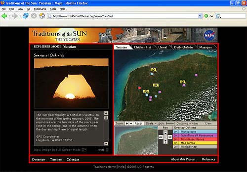
Figure 5. Screen shot with the three main areas of the page delineated in red.
As much as I admire the overall execution of this project I do have one big doubt about the technical design. In itself, the technical side of the web site does not present problems; however, it does exclude the visually impaired section of the population. Flash can often cause problems for screen readers. Additionally, even on the home page most of the links are image-based making them useless for people with screen readers. I tested the site with WindowEyes 4.3 and found that even basic navigation was almost impossible. I realize that the strength of this site is in its visual contents and applications, but the textual information could be presented in a text-only version of the site. Further, any company that can put together something as well developed and designed as this project on the visual level, should rise to the challenge of developing something equally interesting for those who cannot make use of the visual elements of the web site. This lack of care is annoying given that the site is clearly designed for the general public and the project partners include government agencies.
Overall the Traditions of the Sun web site is wonderful for the general public, which is the target audience. It is also an interesting stop for the casual student. The text is too limited for the student or professional but acceptable for those who only have a passing interest, and some nice general references are provided for those who wish to delve further. A fascinating array of images, QuickTime VRs and time-lapse movies compensates for the lack of textual information.
The site is generally well conceived, well designed and easy to navigate. With the exceptions noted above I had a great time exploring this web site, and I think most of the public will too. It's a great tool to get people interested in archaeology.
-- Sarah Rothwell
To send comments or questions to the author, please see our email contacts page.
For an index of other CD and Web site reviews available on the Web pages of the CSA Newsletter, see the review index.
For other Newsletter articles concerning the use of electronic media in the humanities, consult the Subject index.
Next Article: Scanning 35 mm. Slides in the Office -- An Addition
Table of Contents for the Fall, 2005 issue of the CSA Newsletter (Vol. XVIII, no. 2)
 Table of Contents for all CSA Newsletter issues on the Web
| CSA Home Page |