
|
I have rather often been asked to assist scholars in preparing for CAD work on an excavation. Too often the initial conversation about the project is a strange dialog wherein the questions that seem to require technical answers actually require archaeological ones. That is, one natural assumption of the archaeologist is that the use of CAD is a technical matter and that all questions about its use are related to the application of the technology. In reality, however, the hard questions are not technical; they are questions about the way archaeology is to be practiced, whether CAD is used or not.
The crucial question involves the issue that may be called data density — a technical-sounding phrase for a simple notion: how many surveyed points are required for making a model of building remains or a trench? When a hand drawing is made, several points are surveyed and plotted on paper; then the intervening lines are drawn, either in the dig house or on the spot while looking at the building or trench. When a CAD drawing is made, on the other hand, the same points may be entered and plotted, but straight lines are the easiest way to connect them. The result is less elegant but not less accurate. Indeed, it may actually be more accurate, since the measured points can be more easily discerned, leaving no doubt as to what was surveyed. The appearance of such a drawing is, however, inelegant to say the least. The paper drawing, particularly if the remains in question are irregular, looks very different from the CAD version of the same material. Both may start with the same points, and the CAD model may be more complex in some ways (the model will probably be three-dimensional, for instance), but a drawing from the CAD model will not look the same.
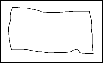
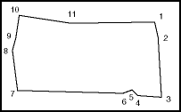
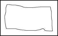
Figures 1, 2, and 3 show a simple case to illustrate the problem (without scale, north arrow, or any of the other information that would be part of a complete drawing). A single irregular stone, which might be a paving stone or a wall block, is shown as if drawn by hand and as if modeled with a CAD program. The measured points are the same; there are eleven of them, numbered clockwise starting from the upper right. Their positions are more obvious in Figure 2, where they are labeled. However, the hand-drawn version, Figure 1, reflects the irregularity found when the stone was examined, as does the more complex CAD version in Figure 3. In the first CAD drawing (Fig. 2) the lines are straight from surveyed point to surveyed point, and much of the real shape of the stone is missing. On the other hand, additional data points exist in the hand-drawn plan and in the second CAD drawing, data points that have become part of the plan without the aid of measurement.
 |
 |
 |
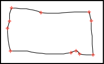 |
| Fig. 1 - Drawing of block, as if drawn by hand. | Fig. 2 - Simple CAD drawing of the same block, using only surveyed data points and straight connecting lines. | Fig. 3 - CAD drawing with added points. | Fig. 4 - CAD drawing with indicators of surveyed points. |
Using either the hand drawing or the second CAD version, one might take a variety of measurements of the stone by measuring the drawing and applying the scale factor. However, only measurements from one to another of the eleven surveyed points should be taken as accurate. Measurements to any other point(s) are measurements to interpolated points. The second CAD drawing and the hand drawing are similar in this respect. Each implies more information than is actually there. The simpler CAD drawing, on the other hand, does not imply more than has been measured, but it is not attractive.
The CAD version in Figure 3 has an added problem that the paper drawing does not. Using a CAD program and the CAD model rather than a paper drawing taken from the model, any point on the stone can be identified, and distances from it to any other point can be calculated with precision by the computer. While a user may understand the precision limits of the hand drawing, many will associate accuracy and precision with the computer and CAD model, even though using the computer to get measurements to interpolated points — any but those eleven surveyed points — can only provide rough approximations of the real measurements.
The problem brought to archaeology by the use of CAD may thus be fairly simply stated: How should the CAD model be constructed so as to provide drawings that are desirable without seeming to suggest levels of accuracy and precision that are not there? Unfortunately, archaeologists often misconstrue that problem and think that the number of data points taken should be greatly increased for the sake of the technology. That is emphatically not the case, however. As the number of measured points used in a hand drawing is not determined by the nature of the drawing process but by the demands of the remains; so the number of measured points taken for a CAD model should be determined by the nature of the material. The archaeologist must decide how many points to survey, based on archaeological needs and common sense, whether working with paper drawings or computer models. He or she must also decide what kinds of drawings are to be produced, again based on archaeological needs and conventions, as well as common sense.
One way to deal with this problem and to display the "real" data along with more attractive drawings is shown in Figure 4. In this case, two drawing layers were created for the same material. The first contains the actual data points, marked with circles and cross-hairs. The second contains the outline of the stone, including interpolated points. When the two are combined, a user can easily see which points in the drawing represent measured points and which have been interpolated. When the first layer is made invisible, however (Fig. 3), the drawing seems little or no different from any direct paper-and-pencil plan. Other ways to accomplish the same end could be found; the point, again, is simply that the needs of the archaeologist come before those of the CAD specialist or architect.
Knowing the archaeological choices, it is not difficult to devise ways to use CAD that will utilize the data appropriately and produce good drawings; lacking those basic archaeological decisions, however, one is hard-pressed to know how to create a CAD model that will satisfy the archaeologist in charge, and that is the first responsibility of the architect. The questions that are most important — and that must be answered first — are the archaeological ones.
Readers will note that this process implies a different emphasis from that described by Geoffrey Kornfeld and Donald Sanders in the previous article, "Layers upon Layers: Using Adobe Photoshop to Create Period Plans." For me, the measured drawing is the primary record, and the ability to retrieve accurate dimensions is the most important requirement of the drawing. Therefore, CAD drawings are preferred, and hand-drawn, scaled plans are more than acceptable alternatives. Photographs can and do add greatly to our understanding, but, absent photogrammetric techniques such as photo rectification, their ability to convey dimensional information seems to me to be compromised by factors such as point of view, shadows, and perspective distortion. Thus, the plan is my primary document and the photograph a necessary supplement.
-- Harrison Eiteljorg, II
To send comments or questions to the author, please see our email contacts page.
For other Newsletter articles concerning applications of CAD modelling in archaeology and architectural history or the use of electronic media in the humanities, consult the Subject index.
Next Article: Lantern Slides of Classical Antiquity Project
Table of Contents for the Fall, 1999 issue of the CSA Newsletter (Vol. XII, no. 2)
 Table of Contents for all CSA Newsletter issues on the Web