
|
One of the oft-claimed benefits of a CAD model is the possibility of obtaining better dimensional information from the computer. The CAD system will respond to queries with dimensions to the mm. or even tighter tolerances if desired, dimensions that do not rely upon reading scaled dimensions and translating them into real-world numbers. As a result, one may obtain far more accurate and precise information than may be obtained from a scaled drawing, where the scale factor intervenes between the survey information and its retrieval. To illustrate the point, a drawing from the older propylon is shown here as Fig. 1, a plan of the so-called upper courtyard. A scale is included as an aid for printed versions; readers are encouraged to print out the drawing and then to use the scale to determine the length of the longer wall block, marked "A" in the drawing.
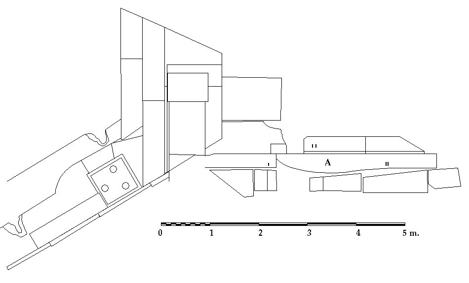
A simple experiment with a 1:20 drawing has also been undertaken to find out how scholars might be able to retrieve dimensions from such a drawing. Four different archaeologists were asked to use the 1:20 version of the drawing in Fig. 1 (as printed directly from AutoCAD® and thus a higher-resolution drawing than the Web image) to determine the length of the block. They produced the following determinations of the length: 3.30 m., 3.30 m., 3.28 m., and 3.29 m. Note that none of the archaeologists attempted to define the length of the block in millimeters, and two may have mentally rounded off to the nearest tenth of a meter. It should be noted as well that the archaeologist who found the length to be 3.29 m. had mis-figured the distance more than once before settling on the final figure. (He was making the measurements in the presence of one of the other participants who rejected his first two or three answers and reminded him of the proper way to read the 1:20 scale he was using.)
The CAD model was also queried to determine the length of the block. The length was found to be 3.290 m. The length determined by querying the model is, of course, the actual length measured in the field, with no adjustment for scale or any other intervening process.
Note that the readings from the drawing were not far off, and one was accurate to the tenth of a meter.1 Note also that the precision of the readings from the drawing would have declined further as the scale decreased. The smaller the drawing, the less precise the measurement. Querying the CAD model, on the other hand, is independent of any drawing or scale factor; the answer is the same, whether one is looking at the stone alone or the entire area.
This has an interesting implication for the future of paper drawings. As CAD becomes more commonly used, scholars will naturally choose to query models for dimensions rather than attempting to retrieve information from drawings. That may, in turn, have some impact on the drawings produced, since they may be considered illustrative but not data sources. The traditional plan, used to provide dimensional information as well as location and layout, may evolve in unexpected ways if the dimensional information is no longer needed.
Should reliance on CAD models for dimensional information become common, there is another implication. Many two-dimensional CAD models have been and continue to be created by tracing hand drawings made in the field or, in some cases, scanning the drawings and tracing on screen or vectorizing with automatic vectorizing software. Thus, a field archaeologist or site architect makes a hand drawing on site, and that drawing is traced or otherwise digitized to become part of a CAD model. That may by done either in the excavation workrooms or after returning to the office/lab.
Such a process of converting field drawings can be very desirable, since all the potential for including multiple phases and reconstructions can be available in a model made from field drawings, and the conversion process does not entail a large loss of accuracy or precision. However, beginning with scaled hand drawings rather than dimensions or survey data necessarily degrades the dimensional precision of the resulting CAD model to some degree. The source data are no longer coordinates or dimensions, but scaled approximations thereof. That is not a devastating matter. The drawings are still very useful, especially when precision is not critical. It is, however, a problem for anyone who goes to the CAD model expecting levels of precision that have not been recorded. In fact, there is a significant danger that a user of any CAD model will query the model for measurements and assume that the measurements retrieved have the kind of accuracy and precision that are possible with a CAD system. Such a user might rely upon retrieved measurements and make arguments based upon them, unknowingly using inaccurate data derived from traced drawings rather than survey data. False precision, after all, equals inaccuracy.
The potential to misinform in this way is serious. Therefore, CAD models should have accompanying documentation that clearly and unambiguously states the levels of precision involved while also describing in detail the methods used. In that way, any user of such a file could be certain as to the accuracy and precision of the information retrieved from the CAD model. Documentation of this kind is, in fact, so central to the ultimate use of all digital data that its importance cannot be overstated, though creating it is one of the most unrewarding and unglamorous of tasks.
1. All the measurements were very close. Only one was accurate, though the precision was to the nearest centimeter rather than the nearest millimeter. Had the two scholars giving 3.30 m. as the length said 3.3 m. instead, they would also have been accurate, though even less precise. Return to body of article.
For other Newsletter articles concerning applications of CAD modeling in archaeology and architectural history or the use of electronic media in the humanities, consult the Subject index.
Next Article: Scanning Propylaea Drawings
Table of Contents for the Spring, 2001 issue of the CSA Newsletter (Vol. XIV, no. 1)
 Table of Contents for all CSA Newsletter issues on the Web
| CSA Home Page |