|
Paul F. Jacobs, Cobb Institute of Archaeology, Mississippi State University
Introduction
Demanding taskmaster, generous benefactor--that names the experience of the Lahav Research Project's adaptation of (and adjustment to) digital equipment and digital recording in the field. The 1999 excavation season at Tell Halif, in which we made extensive use of digital technologies to recover and record archaeological data, demonstrated the highly valuable and viable role these technologies can play in archaeology; the experience also brought recognition that traditional ways of imagining and carrying out the excavation project are about to undergo significant change. The new digital technology promises a revolution not in excavation technique, but in the perspective of the excavator; because of the potential the technology brings to archaeology, the excavator will necessarily view differently the process of recovery and the artifact record l itself.
Part I. Preparation--planning a digital field season.
Planning for the 1999 season, as an element of LRP Phase III excavations, started some eleven months in advance of the team's arrival on site. Ours was the pre-season task of rethinking all of our standard procedures and reconsidering many of our expectations and rationales for excavating not only at this site but also in principle.
Planning a digital field season--even one appended to an existing archaeological project whose goals and methods had already been tested in previous seasons--entailed significant re-ordering of procedures, staff, and (as we came gradually to learn) research design. During this preparation stage we quickly found ourselves dominated by the new technology, because we had not previously used it so extensively in the field. We had to think through what we wanted the equipment to do, whether those aims would be and whether new methods and goals had to be adopted; answers to these questions led eventually to a new (for us, at any rate) conception of what and how to report findings, which itself fed back into re-formulation of project goals. We believe it is important to take note of the fact that the application of this new technology did not simply make recording more efficient, but that it also helped re-shape excavation and publication goals; the addition of digital equipment to the excavation process is not a neutral event. These devices bring both positive prospects and, necessarily, some limitations to procedures and to final goals.
Our pre-season preparation started with the assumption that, above all, we needed the computers to take the place of the field notebooks; the laptop would, then, mirror daily log page, basket page, and locus description sheets, even to the layout of the screen. And while it is technically possible--even relatively simple--to reproduce our traditional notebook pages by creating a series of separate "fill-in-the-blanks" screens, it soon became clear that the digital version of the field notebook offered much more benefit than a simple "paperless" excavation. Here began the transformation of our thinking about digital equipment in the field.
Urged by staff computer experts, we began to ask if the software could actually manage the recording of data for us, not simply act like a neutral electronic slate onto which we deposited numbers and field observations. By linking the computers in the field and labs to a "server" laptop (also located physically in the field) we could and did, in fact, manage recording procedures. The server monitored data entry as it occurred, assigning to each new locus, basket, or material culture collection a discreet identification number (eliminating at once duplicated or skipped number assignments). Supervisors (and, early in the season, the volunteers assigned to their teams) began entering data using uniform descriptions available in drop-down windows for each "blank" that required information. But more importantly, the constant updating of data by the server could (and did) make information immediately available at all stations in the network.
This sharing of information meant not only that a technical illustrator in the lab could report progress to the field, or that the director could keep an eye on progress in several parts of the excavation from a single monitor, but especially that data (here, measurements, precisely determined locations of artifacts and architectural units, technical descriptions, Munsel colors, etc.) could be used while the excavation teams were yet in the field to generate reports, to track disposition of artifacts, to construct three-dimensional representations of soil layers and architecture, and to check precise locations of artifact finds. Because these data sources were constantly updated as entry was made in the field or lab, feedback of valuable information to field and lab personnel could be immediate. At every moment at each station all information was available to any user. Microsoft Access was selected to manage the data and to maintain the server and the various stations.
Because renderings of the data were possible as data flowed to the server, an urgency for more frequent and more precise measurements and locations worked its way into projected daily excavation routines. While increased diligence and frequency in ordinary excavation procedures guaranteed to slow down the daily digging processes, they also promised significant benefit to offset loss of excavation time. That promise was fulfilled regularly during the excavation season.
Part II. Setting up the digital field.
In deciding to use digital equipment extensively and integrally to excavation itself, we established a number of goals for the season:
 Fig. 1 - Western edge of Halif. Field IV in foreground. |
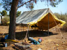 Fig. 2 - Tent erected as a shelter for the server. |
To test and to meet these goals meant setup of equipment in the field and in the
lab in nearby Kibbutz Lahav. Excavation fields were chosen at the near-maximum
distance at which a local area
network could be expected to work successfully. Two excavation teams were
established in Field I on the eastern slope of the tell and three teams in
Field IV on the western slope approximately 225 meters away; each field used a
tent to shelter the electronic equipment from the sun. Midway we constructed
a
tent as shelter for the server. The labs were located in a building in
Kibbutz Lahav, another 150 meters from the server. A power line from Kibbutz
Lahav was strung through trees and finally across the ground to the three field
stations. Finally, all of the
computers were linked using a combination of 10baseT and coaxial cable. Power
units located strategically in the cable connections to boost signals from
machine to machine allowed the flow of data to be essentially uninterrupted
during the workday; the few "down times" experienced were quickly
corrected by the computer staff.
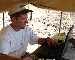
To expedite handling of artifacts, as well as to establish the central point from which these would be controlled, the registrar's work location was moved to the field (from the lab, where traditionally located).The registrar periodically collected artifacts (pottery, bones, flints, figurines, beads, etc.) and entered basic information into the database before the materials were sorted for different locations. Later in the day, as the materials were further treated (washing, drawing, description, photography, etc.), additions were made to the database for each object or collection. Other staff--e.g., photographer, technical illustrator--worked in the lab but could follow the status of the excavation by accessing the database.
Work with the excavated materials continued in late afternoon, a time for artifacts to be cleaned and read by the staff. By that time the computers had been brought from the field for service in recording pottery readings, entering additional notes, scanning completed drawings, and collecting digital photographs, all added to the database records.
Because of the experimental nature of the 1999 field season (not knowing how this extensive use of digital equipment would affect excavation, or whether it would fail to handle data), both the duration of the season and the size of the excavation team were limited. Our four-week digging season with 28 staff members was also limited to excavation of those locations we predicted would yield uncomplicated stratigraphy. Of course, in the end our guesses at locations were corrected by the reality of the deposits. Nonetheless, this cautious approach allowed us to adjust software and the disposition of the equipment on the fly.
We included as an integral part of the 1999 season a broad use of digital photography, which for us meant graphically recording data, events, and artifacts far more extensively than is usual for excavation in the ancient near east. We asserted that since it is now possible (and affordable) to report finds totally by digital means, it is also imperative that a responsible excavator do so. This also was to be tested under field conditions. Our setup had to supply the logistics to accommodate photography on a large scale. Our equipment included a Minolta RD175 35 mm. camera with digital back, a hi-8 Sony video camera, backed up with 35 mm. print and slide cameras; other "point and shoot" digital and traditional cameras were assigned to field supervisors with the instructions to photograph frequently.
Part III. Digital excavation in practice.
Here I would like to say that all went as planned, but the truth is something different. The digital equipment proved both blessing and headache.
In the first instance we anticipated that field supervisors, conditioned to record information in notebooks in traditional formats, would require a long time to adapt to the look and feel of the computer in the field. To be certain not to lose information during the transition to computer-based recording, I assigned supervisors to record in both notebook and computer, "until we could determine if the computer-based system would work for us." The supervisors--and their team members--were far less cautious than I. They abandoned the notebook in the first week, because entry of data was so much simpler (and more complete) via the computer. Notebooks were relegated to the role of fly-swatters. We achieved the goal of a "paperless" excavation almost immediately. Indeed, the rapid adoption of the computer in field and lab allowed computer technicians to make adjustments to the Access program to reach clarity, simplicity, and completeness. Though recording remained a critical ingredient of the process of excavation, that is, it demanded constant attention from the supervisor, the ease of data entry actually freed supervisors for time in the trenches. However, the increased frequency, detailed quality, and usefulness of the data also demonstrated that we needed twice as many computers as we actually had in the field. (We took six laptops.)
Much to our pleasure--and somewhat our surprise--the computers also "managed" the data very well. That fact may have been because of the cleverness of the computer staff in constructing a database that integrated and reported so well. Nonetheless, we found end-of-season reports simple to prepare, interim reports ready in an instant, the tracking of objects routine. In addition, because all data were interpreted by an in-house program to give field personnel three-dimensional representations of the excavation in progress, errors in mathematics otherwise not visible until the writing of the report (e.g., the addition, rather than subtraction, of two numbers to determine height above sea level) became immediately visible to staff. If a three-dimensional unit (locus) of soil appeared on screen to be a meter above the height of the tell, then it was clear that an arithmetic difficulty has been encountered by the program; corrections were entered while memory of the event was fresh. This same three-dimensional representation also permitted viewing of artifact find-spots on screen; by rotating the model supervisors could detect clusters of artifacts and potentially predict the location of others, e.g., figurines. This three-dimensional model portrays artifacts, "baskets" (smallest unit of excavation), loci (soil layers or architecture), excavation areas, fields, and the tell.
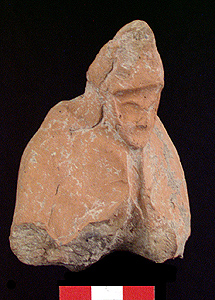
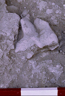
Predictions that careful selection of excavation areas could protect us from an overwhelming flow of data, artifacts, and stratigraphic problems proved to be less than accurate. The situation with one artifact-type will illustrate. On the basis of previous seasons, I had predicted that we would recover in Field IV as many as 100 artifacts of the Persian era ceramic figurine type. Though we had recovered some 500 figurine fragments in Field IV in the 1992 and 1993 seasons combined, in the 1999 season a fraction of workers in a fraction of the time and in a severely limited space surely would restrict that number! In fact, we recovered approximately 350 figurine fragments. The system meant to handle artifacts in a steady flow from field through posting on the web as digital photographs was overwhelmed. Here, too, we found we needed twice as many photographers and digital cameras to handle the materials. The unanticipated quantity of data and artifacts thwarted our intention of quickly recording finds by digital photography.
We had intended, also, as a part of our experiment with digital recording, to address the problem of long delays in reporting excavation finds. The Lahav Research Project had already attempted to report finds early by placing all of its data from the 1992 and 1993 seasons on a web site (www.cobb.msstate.edu/dig). For the 1999season we had planned regular (daily) postings of data, photos, drawings, etc. on the same web site. Here, too, our plans were stalled; connection to our server at Mississippi State University was broken repeatedly, often after only a few minutes; hence, the aim to disclose data and finds early and regularly failed. With more reliable communication systems on-site, we continue to believe, this goal would have been realized and provided useful information.
Conclusion
While this article has concentrated on use of digital equipment in the field, it has also hinted at broader issues. Of, course, staff makeup must be modified to use the new technologies; not only will the excavation staff include experts in software and equipment, but because of the emphasis on digital publication as the end-game, much more attention will be given to accumulating and managing the digital data; more staff members than before will work on preparation for final publication while still in the field to manipulate, prepare, and archive the thousands of photographs, to scan, size, and archive architect and artists' drawings, etc. Because so much more can be done with the excavated material, additional technical staff must be added to the team.
Most importantly, it is now possible for a project to show/publish digitally all its information through emerging technologies./p>
Because digital photographs are easy and inexpensive to create and duplicate, graphic representations of artifacts, trenches, structures, etc., need no longer (should no longer) be restricted to a few examples, as in traditional (print)publication. All relevant data should be published, including digital representations of all examples of an artifact type. This means, of course, that published digital data becomes statistically reliable, since the statistics will not be skewed by selectively published material. With full reporting feasible (we believe, required), the very approach to excavating the soil is necessarily affected. The end product--the final report--looks significantly different under the decision to record and report via digital media. Technology here modifies field and research strategies. When we left the field at the end of the 1999 season, we did so with a significantly different view of archaeological methodology as a result of our first full venture with digital tools
-- Paul F. Jacobs
Cobb Institute of Archaeology
Mississippi State University
To send comments or questions to the author, please see our email contacts page.
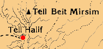
Tell Halif
|
 |
Tell Halif Identification
Tell Halif (modern name) is a 7.5 acre site some 16 km. north of Beersheva, that has been variously identified as Ziklag (Abel 1938; Seger 1984), Tilla of Eusebius' Onomasticon (Abel 1938), Goshen (Aharoni 1967), Hormah, and Rimmon (Kloner 1980.) Though there is no consensus on identification, circumstantial evidence tends to support the Biblical name En Rimmon (Joshua 19) and Byzantine era Rimmon (or Tilla), located by Eusebius some 30 km. south of Beit Guvrin. The geographical location of Halif appears to correspond to the list in Joshua 19 and to Eusebius' placement of Rimmon. The lack of Philistine remains at Halif argues against its identity as biblical Ziklag (Oren 1982). Kloner (1980) argues that because Hurvat Rimmon (two km. south of Halif) contains no Iron Age remains, it cannot have been biblical En Rimmon; Tell Halif, however, was occupied in both Iron I and Iron II periods. Kloner suggests that the name Rimmon had been borrowed from the older tell site to name the Byzantine village, while the name Tilla ("the tell") was applied to the original site of Rimmon (i.e., Halif.)
Abel, M. 1938. Geographie de la Palestine. II. Paris.
Aharoni, Y. 1967. The Land of the Bible: A Historical Geography. London: Burns and Oates.
Kloner, A. 1980. Hurvat Rimmon, 1979, Israel Exploration Journal 30: 226-228.
Seger, J.D. 1984. The Location of Biblical Ziklag: An Identity Crisis, Biblical Archaeologist 47: 47-53.
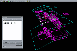
| Tell Halif DigDug John Vander Zwaag created a three-dimensional recording and display system (which he named DigDug) that automatically retrieved data as it was entered in the database. DigDug then represented the data as points (for objects) or as three-dimensional cubes, lenses, or spherical shapes (for soil layers, pits, walls, floors, etc.). On-screen representations of all of the excavation units appeared and changed from moment to moment as new data was recorded. |
 |
|
A glance at the available screens showed activity in the field.
Supervisors, therefore, could determine immediately if measurements were entered in error, since DigDug represented the artifacts and excavation units as their locations were actually keyed into the database. With zoom and rotating capabilities built in, DigDug became a vital aid to accuracy in recording and to excavation. An unanticipated benefit of the three-dimensional plotting of the artifacts (visible on-screen by types, represented by color assignments) was that it became possible to predict the discovery of artifacts based on the clustering of artifacts that appeared on-screen. For example, the clustering of ceramic figurines along the western limit of Area J7 (one of our units of excavation) allowed us to predict that a still larger number would be found in the same soil deposit immediately to the west; a prediction verified by excavation.
The screen of DigDug shown at the left is a representation of loci within excavation areas (green). |
For other Newsletter articles concerning the use of databases, electronic publishing, or the use of electronic media in the humanities, consult the Subject index.
Next Article: Slide Digitizing - More Exacting Experiments
Table of Contents for the Spring, 2001 issue of the CSA Newsletter (Vol. XIV, no. 1)
 Table of Contents for all CSA Newsletter issues on the Web
| CSA Home Page |