
|
|
|
|
Since 1990, Minnesota Archaeological Researches in the Western Peloponnese (MARWP) has undertaken an architectural study in the western Peloponnese of Greece (known as the Morea in the Middle Ages). This project consists of a survey of vernacular architecture from the period of Frankish occupation in the 13th century A.D. to the present. Our research seeks to discover, document, and study a variety of previously unrecorded buildings and towns before they are destroyed by man and nature. In this article, we discuss how the application and integration of GIS and GPS is aiding MARWP in the identification of undiscovered medieval sites and the distribution and development of vernacular architecture.
At the beginning of the 13th century, large parts of Greece were conquered and settled by Crusaders returning to the west following the last Crusades in the Holy Land. These conquerors, commonly called Frangkoi or Franks by the Greeks, were a mixed population of different European nationalities. While much of this conquered area soon regained self-governance, the Peloponnese, which became known as the Morea, was occupied intermittently from 1205 through the 1440's. During the two centuries of Frankish presence the conquerors constructed numerous churches, large fortifications, and domestic architecture in unfortified towns.
The Frankish occupation of the Morea had attracted little interest until recently. As with other historical Greek periods, some Frankish remains had always been visible (Fig. 1), but many remained hidden under dense vegetation in mountainous terrain. Medieval sources documented this period of Frankish domination, but many are just now becoming accessible to interested scholars.
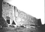 Fig. 1 - Stone fortification wall from the
Frankish site of Chlemoutzi
Fig. 1 - Stone fortification wall from the
Frankish site of ChlemoutziEarlier expeditions in the Morea before MARWP had diverse goals and methods, and they met with varying degrees of success. In the 1950's, Antoine Bon traveled the Morea and located a number of Frankish citadels and settlements which he plotted on a map of the region. He could not, however, locate many of the sites named in Medieval records and thus only approximated their positions on his plan. The locations of many of these sites remained unknown into the early 1990's.
Traditional pedestrian reconnaissance had also been utilized as a means of site recovery. The Minnesota Messenia Expedition (MME) canvassed the southern region of the Morea in this way during the 1950's and 1960's, but their interests were focused on much earlier periods. Other surveys often overlooked sites because of limited ground visibility and the overall inaccessibility of sites - many of which were high in the mountains.
The majority of Frankish sites have been located accidentally through excavation. A good example of this is the excavation at the ancient city of Corinth where trenches exposed Frankish buildings rather than the expected perimeter to a Roman temple and sanctuary. The Frankish occupation of Corinth dates from the 13th to the early 14th centuries A.D. and was undocumented until its accidental discovery in the 1980's.
Until a decade ago, architecture such as that found at Corinth was essentially ignored by modern scholars. Scholarship focused primarily on the handful of previously documented sites located in areas of easy accessibility. The resulting effect was a skewed understanding of the Frankish presence in the Morea, favoring sites that were easily accessible and previously documented. By the late 1980's the need for a more comprehensive study of the region was understood and a program of site location and analysis was begun by MARWP.
The detection and analysis of kastra (citadels) and accompanying towns occupying a geographic area of 10,000 square kilometers is an undertaking which simply can not be accomplished by the methods used by Bon, by the MME survey, or by on-going excavation at a classical site such as Corinth. Integrating GPS with spectral analysis of remotely sensed data offers a superb alternative. Our study has adopted this methodology for archaeological prospection and analysis to cover a broad range of data over a large and topographically diverse area. Obstacles such as hilly terrain (Fig. 2), dense vegetation, and the inevitable destruction of built forms by both natural and man-made forces make it difficult to achieve a satisfactory level of comprehensiveness using traditional engineering survey techniques. It is only with the full integration of Landsat satellite image processing, Global Positioning System (GPS) technology, and Geographic Information Systems (GIS) into our research program that we are able to undertake these broad and varied projects.
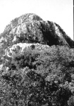 Fig. 2 - Hilltop and mountainous terrain in
the Morea
Fig. 2 - Hilltop and mountainous terrain in
the MoreaIn 1990, we began our study by consulting census records dating from the 1400's through the 1700's. Sites mentioned in these records as well as others identified in Antoine Bon's study of the Frankish architecture of the Morea were examined on the ground, pinpointed with the Global Positioning System, and located on satellite photographs in the following summer.
Methodologies developed in the field of phytoarchaeology were then integrated into our research strategy to define a relationship between particular types of vegetation and extant architectural remains. This relationship is expressed by a direct correlation between the abundant growth of prickly oak and holly near fortification walls. The examination of histograms and scatterplots of the near- and mid-infrared channels of the satellite scene has shown that the spectral response of the incumbent prickly oak, which obscures the walls from view, has a distinctive spectral signature that can be used to identify the presence of walls. This correlation enabled the extraction of a reliable spectral signature for built stone fortifications and citadel walls by image processing of our satellite scene in 1991. The signatures that were extracted in this way were then used to classify a subset of our satellite scene.
In the summer of 1992, we tested the accuracy of our classification by checking at first hand some of the sites identified in the lab. Because reliable topographic maps for the Peloponnese were not yet available, location of sites was limited to areas near recognizable topographic features. This early classification resulted in the location of two uncharted Frankish citadels in an area at the southwest end of the Erymanthos ridge, in the modern province of Achaia.
Kastro Tis Oreias, one of the sites MARWP detected, rises above the gorge of the upper Peneios River and was an uncharted site of some importance. The site is now desolate, occupied only by a single shepherd and his family, but seems to have been a thriving industrial settlement as indicated by the remains of 240 houses, three churches, a cemetery, sixteen mills along the river, and copious iron slag.
After this initial test application we continued testing our methodology and successfully located five of five possible sites. After verification through field reconnaissance, these sites were sampled and added to our base of recorded sites to be used for a supervised classification of our Landsat satellite scene.
During the same season, a staff member scanned newly available Greek Army Geodetic Survey maps for suggestive toponyms located in terrain suggestive of possible Frankish occupation. The increased accuracy of these new topographic maps for the Peloponnese enabled us to geo-reference our satellite scene in the spring of 1997. Using UTM coordinates obtained during mapping, we compiled spectral signatures for specific architectural and archaeological features that were identified and sampled in the field. Evaluation processes were utilized to obtain a tight overlap of spectral characteristics to highlight those areas that conformed to the spectral signature of these training samples - in other words, potential sites. This supervised classification has allowed us to define specific areas that conform to the outline of fortification walls and citadels. Sites located through the analysis of aerial photography and site toponyms are currently being used in this procedure as test sites for our classification.
In August of 1997 we physically examined a portion of our study area that contained a high concentration of the classified spectral signatures. This area was not associated with a site toponym but appeared to have a strong likelihood for site location based on the clustering of "hot" or classified spectral signatures. Using UTM coordinates gathered in the lab a MARWP field crew successfully navigated to the location and verified the presence of a previously undocumented medieval settlement, located near the small village of Ano Salmenikon.
Concurrent with our study of medieval Frankish citadels is our survey of standing vernacular architecture in the Morea. This project examines the methods and materials of construction that date from the Middle Ages, if not earlier, and which continued until the 1950's when the widespread adoption of the concrete frame replaced these centuries-old construction techniques. We hope to develop a chronology of traditional Greek building as well as to illustrate some of the methods by which architectural styles were transmitted across geographic areas. To streamline the recording process over this large area, we have developed a method which combines traditional and electronic means of surveying and mapping. The use of standardized survey sheets, along with the GPS, makes it possible to survey and record architectural features in the villages at a rapid pace. Prior to the survey of a village by the drawing team, two or three persons walk through the village, marking a series of waypoints that are entered into the GPS as they go. This information is downloaded into AutoCAD and a preliminary map showing an array of waypoints is generated. Some of these points are joined to produce roads, others are interpolated to generate contours and topographic features. These maps are then used by the drawing team to navigate through each village as they record the buildings on the survey sheets. On these forms, team members sketch the plan and four façades of each house, and note the size, placement, and orientation of windows, doors, and outbuildings.
The encoded data collected for each house is then transferred to a combined graphics and database system, from which representations of each façade are produced. We are currently involved in the process of integrating this data into a GIS database. Using this technology it will be possible to initiate a query on individual architectural features, such as the architectural decoration in figure 3, that are found in a particular village and relate them to any village in the database. For example, a certain style of lintel construction, dated to a particular period, can be used as a query criterion. Any house that possesses this feature will be among the responses to the query, and the associated data can be displayed or printed for further analysis. The distance between houses with similar attributes is automatically calculated and displayed.
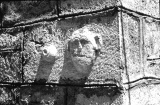 Fig. 3 - Architectural decoration on a house
exterior documented through the survey of vernacular architecture
Fig. 3 - Architectural decoration on a house
exterior documented through the survey of vernacular architectureThis application of GIS technology has significant merit in the analysis of traditional vernacular architecture. It is not only possible to chronicle the spatial distribution of a particular architecture style from one village to another but also to analyze the interrelationships of this style with others that date to the same period and that occur in the same villages. Using date stones, we are able to establish a chronology for specific architectural styles that can be entered into our GIS database. The movement of individual stone masons and architects can thereby be associated with the movements and perceived economic viability of their contemporaries.
The development and analysis of data using techniques discussed in this article is an ongoing and developing process for the Minnesota Researches in the Western Peloponnese. But even at this level, the integration of GIS and GPS into our methodology has allowed us to expand beyond the limits and constraints of more traditional surveying techniques and has enabled us to interpret and expand far beyond the production of topographic maps.
Todd Brenningmeyer
Dept. of Art History, University of Minnesota
Frederick Cooper
Dept. of Classical and Near Eastern Studies, University of Minnesota
Caitlin Downey Verfenstein
Dept. of Classical and Near Eastern Studies, University of Minnesota
For other Newsletter articles concerning the applications of GIS in archaeology and architectural history, consult the Subject index.
Next Article: Pottery Profiles - Yet AgainTable of Contents for the Spring, 1998 issue of the CSA Newsletter (Vol. XI, no. 1)
 Table of Contents for all CSA Newsletter issues on the Web