
|
Two-Dimensional Plans versus Three-Dimensional Models with CAD
All CAD programs can be used to make plans or elevations without 3D features; most -- but not all - can also be used to model three-dimensional objects in all their three-dimensional complexity. For people who are interested in ancient architecture, the use of 3D programs to make 3D models is a given in most instances. However, the use of CAD for excavation drawings may or may not require the use of 3D features. In some cases the additional time and trouble required for 3D models may not be justified by the real gains in information or visualization potential. In others, there may be no real benefits at all. In still others, there may simply be no effective way to model three-dimensionally the parts of the excavation.
Modeling in 3D is not an either/or question. It is quite possible, in fact normal, to mix 3D modeling with simpler 2D elements. Therefore, creating two-dimensional plans or three dimensional models may be a choice arrived at for an entire project or only for parts of a project. In either case, survey needs and, consequently, survey techniques may differ according to the modeling expectations. The decisions about the use of 2D plans and 3D models should be made with care and forethought -- and well before the beginning of survey work. At the same time, though, plans must not be so rigid that change is impossible. For that reason, it is virtually always better (safer) to choose software that permits 3D modeling, thus keeping all options open.
On what grounds shall such a choice of 2D or 3D CAD be made?
1. Operator skill. This is not a good reason to avoid the use of 3D, but it is better to work within the competencies of the CAD specialist than to pretend that significant skill and experience limits do not exist. A good set of 2D drawings will be more useful than a poor 3D CAD model. Indeed, a 3D wire-frame model may be so confusing as to be difficult to use at all, and inexperienced CAD personnel may not understand the difference between a 3D wire-frame model and a surface model.
2. Survey equipment. This is another poor but real reason to limit CAD modeling to 2D features. If the available survey equipment will make it impossible or effectively impossible to obtain 3D coordinates for virtually all surveyed points, then attempting to model in 3D will probably be fruitless.
3. Time and/or money. These, too are unfortunate but real reasons to choose to adopt 2D recording and drafting techniques. If funds or time will not permit 3D recording and modeling, it would be a mistake to pretend that those limits can be ignored or circumvented.
4. The nature of the excavation. This is the most important variable, since it is the one that requires the most careful and self-conscious examination of the choices at hand. This is also the most important of the variables because it has so many individual aspects.
4a. Dealing with excavation units can be very demanding for a CAD specialist, but a great deal depends on the nature of the survey data to be provided and the kinds of finished drawings the project director wants. For instance, if an excavation unit is defined by surveyed points around its perimeter (top and bottom) and surveyed points from its bottom surface (and by the surveyed points from the bottoms of superposed units), the boundaries can be modeled as surfaces (the minimum for a 3D model) or the whole unit can be made into a solid (neither necessary nor recommended). The result, however, may not satisfy the excavator in terms of the aesthetics of the finished drawing. Here, for instance, is such an excavation unit (a pit), this one defined by a dozen points along the top and bottom of its perimeter and three points for the interior of its bottom surface. The appearance of this excavation unit is almost schematic because straight lines connect each surveyed point, but, unlike the adjacent plan view that might be created in a 2D setting, all evident points are actual surveyed points, complete with retrievable coordinates. Those coordinates provide real geometric information. The more traditional and attractive drawing, on the other hand, is based on the same data points, but intermediate points required for the more naturalistic lines have been included. They may also seem to be surveyed points even though they are simply drawn to reflect the appearance of the unit, not surveyed, and that could lead to confusion for someone using the CAD model (not a scaled drawing but the model itself) to obtain dimensions or coordinates. For a discussion of including surveyed and non-surveyed points within the same model, see Harrison Eiteljorg, II, "Using CAD on an Archaeological Site" CSA Newsletter XII.2 (Fall 1999) at http://csanet.org/newsletter/fall99/nlf9905.html.
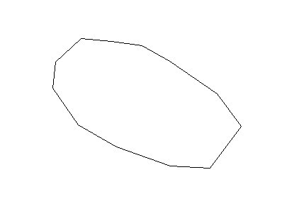
Fig. 1 - A pit outline drawn exclusively with surveyed points so that
the complete 3D representation of the pit can be modeled. Each point
could be queried in a CAD model to obtain survey coordinates.
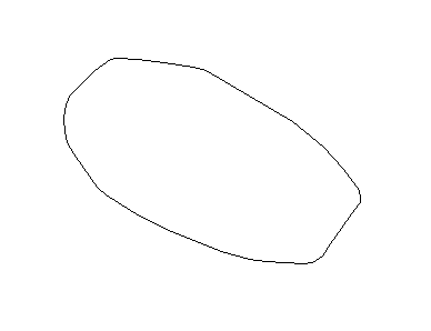
Fig. 2 - The same pit as in Fig. 1, but the outline here has been drawn
with surveyed points plus other points selected during the drafting
process to create a more naturalistic outline. Even using the CAD model,
it would not be possible to determine which points had been surveyed
unless some provision had been made to mark surveyed
points and distinguish them from added points.
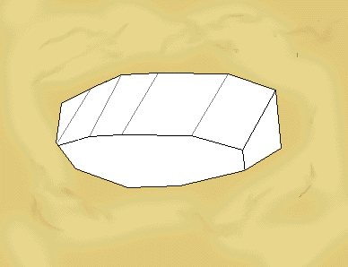
Fig. 3 - The same pit modeled as a fully 3D object, with depth and
sides, and viewed to show its three-dimension features. The pit
is shown as a lone excavation unit penetrating otherwise
undisturbed earth.
There is an additional problem with the 3D version of this excavation unit. Since the top and bottom of the unit are not identical except for elevation, a plan view is much more complex than a plan view of only the top or bottom. The shape of the top and bottom must compete in the viewer's eye, making the drawing more difficult to understand.
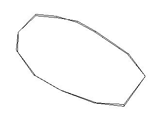
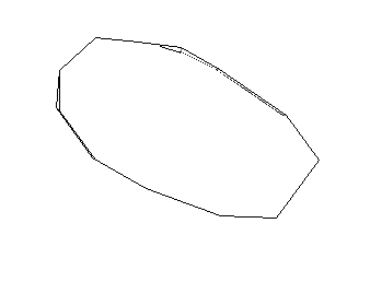
Fig. 4 - The 3D model of the pit seen in plan view in two representations. On the left is a simple view that includes both the top and bottom boundaries of the pit. On the right is a plan view (a so-called hidden-line view) that shows only the upper boundary and the portion of the lower boundary that would be visible in a plan view. Neither view is as easily understood as a simpler view of only the top boundary of the pit.
If one is satisfied with the results of this 3D process, then 3D modeling may be appropriate. As an alternative, one may rely on the 3D model for analysis, but use it as only a starting point for hand-drawn publication drawings, the starting points for other kinds of computer-generated drawings (using illustrations programs to modify CAD drawings for instance), or the base to overlay photographs that provide the missing irregularity.
4b. Dealing with features that either lie in or help bound excavation units presents another set of challenges. Those features are most likely to be very irregular. As a result, modeling them accurately is very difficult and may require more data points than are warranted or more simplification than is desirable. (A more irregular pit than the one shown above would create similar problems.) A small group of rough stones, for example, as modeled for work on the Acropolis and shown in Fig. 5 may be all but impossible to model correctly. These have been outlined more or less accurately from field drawings but their tops and bottoms have both been modeled as horizontal, which is obviously not correct. It is, however, the best that could be done with the evidence at hand -- and probably represents as much information as is required about those particular blocks.
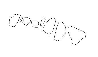
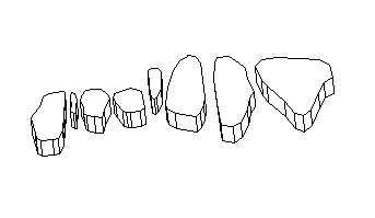
Fig. 5 - Stones forming part of a Mycenaean terrace wall on the Acropolis, shown in plan view, above, and as 3D models with horizontal top surfaces, below.
A standing wall of rough stones may also require substantial simplification, as shown in Fig. 6. In this case, the outlines of the blocks have been properly surveyed, but there are no surveyed points for the interiors of the faces; so the boundaries of the faces are accurate but the undulations of the surfaces that make up the faces are not -- because the outlines provided the important information about the nature of the wall and its disintegration, and the individual surfaces that combine to make up the faces would have been of little or no value for the project. In this case, the faces have been treated nearly as summarily as the tops of the terrace wall blocks shown in Fig. 5.
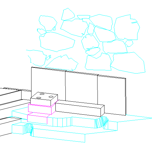
Fig. 6 - The area near the Acropolis gate in the second quarter of the fifth century B.C.E., with the Mycenaean wall blocks surviving from the older fortification wall shown in cyan, behind the marble blocks set up later to beautify the area.
4c. Mud brick or adobe structures present another kind of challenge. The challenge is more archaeological than CAD-related, however, because the real issues are how many points to survey and where to take those points. The same issue of generalizing complex shapes is present, though. A long stretch of wall may be slightly irregular as well as partially decayed, and surveying such a wall must be done with the archaeological questions in the forefront: what points need to be surveyed to define the wall accurately and effectively? The secondary question for the CAD specialist is critical for model-making but must be considered truly secondary: what points are needed to enable the construction of a 3D model?
The general issue here should surprise no one. The more irregular an item, the more difficult it is to model. Each archaeologist will have his or her own special example of the problem. Therefore, excavators, their architects, and their surveyors need to think carefully about the kinds of materials they will encounter, the kinds of drawings they want, and the methods with which they are conversant before deciding when and how to use 3D modeling and when and how to record their finds as 2D drawings instead. The technology today will not permit the accurate modeling of irregular objects at reasonable costs in time, money, computer power, and model size; scholarly use of that technology must reflect an intelligent and thoughtful compromise that will provide as much information as the scholar needs and wants with as many 3D visualization possibilities as required. Hoping for the moon is ridiculous, but settling for less than needed is unnecessary.
For other Newsletter articles concerning the applications of CAD modeling in archaeology and architectural history or the use of electronic media in the humanities, consult the Subject index.
Next Article: Electronic Survey Using TheoLt® at Whitby Abbey Some Personal Observations
Table of Contents for the Winter, 2003 issue of the CSA Newsletter (Vol. XV, no. 3)
 Table of Contents for all CSA Newsletter issues on the Web
| CSA Home Page |