
|
Electronic Survey Using TheoLt® at Whitby Abbey
Some Personal Observations
David Hunter
TheoLt is bridging software that creates an interface between a total station electronic survey instrument and AutoCAD® running on a field computer. With TheoLt the total station becomes an input device just like a keyboard, a mouse, or a digitiser puck. This enables real-time digitising of structures using a total station attached to an outdoor-capable computer running AutoCAD. (TheoLt was originally developed by Bill Blake of English Heritage's Survey Branch and Mark Latimer of Barclay Technical Graphics to support field CAD architectural survey work by English Heritage. It is distributed under license by Latimer-CAD.)
The TheoLt software runs alongside AutoCAD and provides a small floating tool bar. While using TheoLt AutoCAD retains all of its functionality; AutoCAD tools such as snaps, layers, and multiple views are as easy to use as if TheoLt were not running.
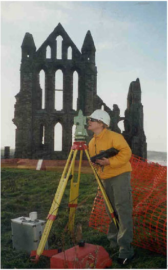
Fig. 1 - Mel Cross with the total station and attached portable computer. The east end of Whitby Abbey is in the background.
Some Experience Using TheoLt at Whitby Abbey
English Heritage's development of a new visitor centre and museum at Whitby Abbey, North Yorkshire, England, posed unique problems for recording standing structures. English Heritage's Centre for Archaeology survey kit (Leica TCR 1105 Electronic Total Station) was augmented with a pen computer, AutoCAD LT, and TheoLt for recording portions of the Cholmley family house that still stand near the Abbey as well as parts of the gardens. (Tom Cromwell, tom.cromwell@english-heritage.org.uk, is particularly knowledgeable about this technology; Mr. Cromwell works for the Centre for Archaeology within English Heritage.)
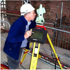
Fig. 2 - The author sighting through the the total station telescope. Note the portable computer attached to the tripod.
Architectural Recording
TheoLt was used to record the inner faces of blocked 17th century windows during the process of opening and refenistration. Each blocking deposit was recorded as a single context entity along with elements of the surviving structure. Modern interventions were also recoded in the same sequence.
The window openings measured approximately 3 m. by 1.3 m. and were up to 0.5m deep.
Brick was employed to face the reveals, and the window architraves were constructed from sandstone. Important features such as the sockets used to secure wooden frames to the stone architraves were recorded, as were historic alterations such as the cutting of recesses or pockets to allow sash windows to be fitted in existing window openings. It would have proved difficult to measure these features accurately using traditional methods.
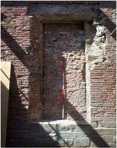
Fig. 3 - A partly re-opened window at Whitby.
The lower part of the 14th century north door to the abbey church was drawn to allow the design and construction of an access ramp. This exercise required not just accurate plan data of complex architectural forms but also elevation data.
Where a crisp arris was encountered, complex structures were recorded at great speed and with great accuracy. Several instrument positions were required to allow for the picking up of detail and to achieve clear lines of to sight around surviving medieval walls.
The recording took about two hours, using a mixture of total station measurements and some hand measurements to fill in inaccessible details. A further hour was spent annotating and editing the drawing before it was emailed to the landscape architect. It is unlikely, given such a complex subject, that any other method could compete on time and accuracy with real-time digitising.
Using the field computer, AutoCAD LT, the total station, and TheoLt increased the speed of recording unexpected features and enabled the gathering of three-dimensional data. The process also helped to focus attention on the development of the structure.
Landscape Recording
The remains of garden terrace and retaining walls were easily and quickly recorded using TheoLt. Since the gardens were built on a series of superimposed terraces, the 3D capacity of electronic survey was extremely useful. Additional detailed drawings were made using traditional measurement techniques and can be added to the wire-frame electronic data.
Using the electronic aids to record earth-cut features such as rubbish pits, cisterns and graves did not prove effective. More time was required to create a reasonable drawing than would have been needed using traditional drawing techniques as it required two staff, a surveyor and an assistant.
Point Density
The amount of detail recorded obviously has an impact on the time taken, and how much detail is recorded can only be decided in light of the probable uses of finished drawings.
A good modern total station will require about 3 seconds to record a point, but transit time to the next measurement may add more time to the process. With practise, one begins to anticipate where the next measured point will lie, reducing the interval. There is also the opportunity to think about the subject, layering conventions, etc. during the interval. In practice, simple subjects can be drawn rapidly, but a real-world stone or moulding is rarely as regular as it can be conceived in the mind's eye.
The irregularities of an edge or surface create a major headache when drawing direct to CAD -- more so than when drawing conventionally due to the increased precision of the measurements. Damage can best be shown with drawing conventions; so using CAD in such circumstances requires anticipating the addition of drawings elements to the CAD results.
Stone-for-stone or brick-for-brick recording was attempted during work at Whitby with mixed results. Brick features were easy to record and, in general, work proceeded quickly. Trying to record weathered stone was altogether more difficult. Edited drawings with additions from field sketches and photographs should improve some of these rougher elements.
Evaluating the Work at Whitby
I found TheoLt to be a great addition to the tool kit for this work. It is not the answer to every building recording problem. It is not a technological panacea. However, by handling many of the repetitive aspects of drawing and allowing access to AutoCAD's powerful tools, it is possible to concentrate on the whole of a subject rather than only the details. It is worth emphasising that the user's ability to select what to draw remains vital, TheoLt does not create the drawing.
Limited lines of sight and lack of definition in a subject were perhaps the greatest obstacles. These are common problems in survey work, and speed, accuracy and familiarity with AutoCAD more than offset these detrimental factors.
Advantages
One soon forgets TheoLt is there, and work proceeds in the familiar AutoCAD environment. Since the working drawing is displayed as it is surveyed and drawn, there is ample opportunity to consider where to position the next measured point, make changes, create and reassign layers.
The advantages of working with a graphic record cannot be emphasised enough. With multiple views including elevations, isometrics, and plans, it is easy to orient oneself to the work and gain a better understanding of the material being surveyed and how it relates to the entire building or wider landscape.
This system was used to produce 3D wire-fame drawings of standing structures, architectural detail, garden features, and, where appropriate, archaeological features. It could just as easily have been used to make plans only or to model surfaces or solids, but standard AutoCAD rather than AutoCAD LT would then have been required on the computer.
Creating the CAD drawing in the field makes it easier to see and understand the processes by which structures evolve and survive. Modern or intrusive features can be removed or imposed on drawings in three rather than two dimensions while the survey work is in progress. This is of great assistance, reducing the time taken during recording and increasing the confidence in the results. It will be of even greater use in the analysis of the development of a structure, since the original survey work will already include more analytic information.
Problems
To a large degree the problems encountered were minor and often involved human and technical factors rather than the TheoLt software. Integrating a pen PC, EDM, and two software applications and then making them work outdoors in British weather is a remarkable achievement.
Some difficulty was experienced setting the orientation of the instrument at the beginning of a survey session. The procedure requires the user to SNAP in turn on the instrument position and reference position symbols in the AutoCAD drawing. The difficulty lay in getting a satisfactory SNAP by tapping on screen with the field computer's pen tool. First one tap then a double tap were required. This simple task seemed almost unattainable at first. All too often a time-out error message appeared; considerable practise was required to get it just right. This was further complicated in cold weather. At temperatures close to freezing a change in voltage in the communications cable prevented communication between the total station and the field computer. This issue has been addressed in the latest TheoLt R2 release. (Of course while wearing gloves in the winter months a slightly altered tapping technique had to be developed!)
Once setup and operating, the software functioned well with only occasional crashes. I can recall only three incidents that resulted in the loss of data. A low battery charge appears to have been the culprit. While frustrating, the solution is to save often and keep the battery charged. (I recommend setting the Auto save in AutoCAD to 5 minutes or less).
TheoLt has a LOCATE function that permits setup and calculation of an unknown position based on a minimum of two known points surveyed from the unknown position. (This procedure is normally called a resection by surveyors.) This is particularly useful when recording inside a building or intensively measuring complex subjects using multiple instrument positions. However, this function is not for the novice or fainthearted. It is a straightforward procedure, but there were several occasions when TheoLt failed to complete a resection. Worse still, incorrect orientations were also calculated a number of times. (Data recorders connected to total stations also perform resections. They usually provide a measure of confidence along with the calculated instrument location. Since the resection relies upon trigonometric functions, accurate instrument set-up, and accurate sightings, errors are not uncommon. They can be very difficult to trace because there are so many variables. - ed.)
Conclusion
Two critical advantages of this equipment and approach are the ability to work in three dimensions, a godsend in work with standing buildings, and the use of AutoCAD, which yields a short learning curve and access to familiar software. Equally important, seeing your subject as a working drawing as you record is at first quite strange but quickly becomes an essential aspect of the assignment. That is, in fact, what makes this approach so valuable in the field.
David Hunter
To send comments or questions to the author, please see our email contacts page.
For other Newsletter articles concerning the applications of CAD modeling in archaeology and architectural history or the use of electronic media in the humanities, consult the Subject index.
Next Article: Database, CAD, and GIS Training Needs
Table of Contents for the Winter, 2003 issue of the CSA Newsletter (Vol. XV, no. 3)
 Table of Contents for all CSA Newsletter issues on the Web
| CSA Home Page |