
|
Harrison Eiteljorg, II
(See email contacts page for the author's email address.)
The Ancient Agora of Athens
URL: project.athens-Agora.gr/index.php?lang_id=gr (Note that the link is the the English-language version of the home page, but the URL shown is to the Greek-language version.)
Authorship: A great deal of information about authorship is supplied at the "Credits" page. Dimitris Efraimoglou is said to have been the "General supervisor or project design and implementation." Many other people are named on this page, and credit is admirably shared. On the other hand, the project is so extensive that it would have been helpful to have had more specific information about responsibility for particular resources, especially the individual models and the individual information pages.
Site host: None explicitly stated but the Foundation of the Hellenic World presumably has its own servers. (While it would be possible to use a web hosting company, the cutting-edge technologies employed suggest in-house servers.)
Peer review: None stated.
Permanence: No explicit information.
Archival procedures: None stated. While this project has been carried out by a large, well-financed organization, the Foundation of the Hellenic World, the absence of specific information about archival procedures is simply not acceptable in today's world. The Foundation's interest in this as a project meant to show the way in its use of computing obliges those responsible to attend to issues such as this.
Languages: Greek and English (only English being examined for this review -- and all spellings being used here are according to those on the site)
Google® has for some time provided ways for users to link geographic information -- and text or visual information as well -- to Google Earth maps, and the Foundation of the Hellenic World has taken advantage of the possibilities to link information about the monuments in the ancient Agora in Athens to Google Earth's world. The monuments in the Agora can be added to the list of "My Places" included in the Google Earth menu. The individual monuments and/or icons can then be included in any view of the area whenever desired. (The file to accomplish this may be found at 3d.athens-Agora.gr/objects/AncientAgora.kml.) The addition of this kind of information to Google Earth's basic geographic data is accomplished via a Google-specified KML file,1 a file type designed for this purpose. It permits the linkage of geo-referenced items to Google Earth and also permits information about the items to be linked to the icons shown in a Google Earth view. When I came across the KML file and downloaded it, I was struck by the surprising amount of information about the first of the monuments I checked, the Monument of the Eponymous Heroes.
In the case of the ancient Agora, a series of icons can be superimposed on Google's satellite image of the Agora. Each icon is positioned at the location of the monument in question and linked to information. There are also 3D representations of many monuments included, and those fuller representations can also be displayed in their proper locations and with the correct orientations. Furthermore, there is information about chronology attached to the icons so that they can be turned on or off according to their dates. This system is sufficiently complex that the icon and the 3D representation can be treated separately. Thus, all the icons can be "turned on" for one of three chronological periods (Classical, Hellenistic, and Roman), one period only at a time. But there is also a sliding chronology bar, and selecting a beginning and ending date will permit a 3D representation to appear alongside the icon if the monument in question was standing between the two selected dates. (Note, however, that the proper chronological period must be "turned on." Thus, if you select a time span outside the limits of the chronological period, the results will be problematic. It is also possible to add the information to a specific instance of Google Earth more than once, complicating the usage in ways that are unintended and therefore will not be discussed here.)
This system provides, within Google Earth, minimal information about the buildings. Rolling the cursor over the icon for one of the monuments will cause its name to display, and clicking on the icon will call a popup window with a short description and, in some cases, a small rendering. Only one popup will be displayed at a time. Apparently size limits on that popup prevent it from containing very complete information, but a link to a web site can be a part of the material in the popup; so it is possible to connect the map to as much information as might be desired, albeit information on a normal web site, not located somehow within Google Earth or the attached KML file. This approach makes great sense, of course; it allows textual information to be organized in an external repository but connected to Google Earth in a useful fashion, and that is the approach taken by the Foundation of the Hellenic World here.
The quality of the renderings, in this reviewer's view, reflect both predictable problems and one surprising one. The predictable problems are those that are, in a sense, built into the technology as we have it today. The models are all hard-edged, machine-made items with all the subtlety and visual sophistication one might expect from a first-year engineering student; sadly, that's pretty much the state of the art today if one feels obliged to take a rendering as produced and without "manual" adjustment via some image-editing software. Added to that mechanical appearance is the fact that there is no wear-and-tear, no dirt, no sense of use or age. Finally, there is the background. When there are other buildings in the background, they provide a larger sense of the setting (albeit with the same hard edges), but the ground and the foliage are lifeless and unreal. The surprising problem is the odd choice of angles on occasion. In particular, the chosen point of view for the Monument of the Eponymous Heroes makes it seem as if the prow of a ship has just come into view, suggesting that it's time to get out of the way -- quickly.
The short descriptions in the Google Earth popup windows have not been standardized to provide some very basic set of information (e.g., dates of erection and end-of-use, general building type, function). The link to further information may make that seem unnecessary, but utility would be enhanced if there were some standard data in each popup, without requiring a link. (Actually, there are two links, one for Greek-language information and one for English-language information.) Selecting a link will bring up your browser with more information in the linked web page. These links take the user to the web site that is actually the subject of this review. (There is another link that takes users instead to the home page of the Foundation of the Hellenic World; it may, at first glance, seem the more logical link to use for more information.)
The link from Google Earth into the web site for the ancient Agora actually takes the user rather deep into the site. It would be difficult to construct a logical path from Google Earth through the entire web site; so let us re-start the review at the home page for the "Virtual Reality Digital Collection: 'The Ancient Agora of Athens,'" coming back to the organization and links between Google Earth and the web site later, but noting here that the quantity of information about the monuments called from the link in the Google Earth view is quite extensive.
The home page is less truly a home page than a basic description the work behind the site. Indeed, it is only the presence of "index" in the page name (and the fact that "http://project.athens-Agora.gr," with no file name required, reaches the same page) that makes me certain this is meant to serve as a home page. It is hard to find the right place to begin from other parts of the Foundation of the Hellenic World's web site, making it seem as if this site had been intentionally hidden. Were it not for the potential, the people involved, and the information in the first link from Google Earth, I might have given the site a pass, thinking it had been orphaned. In addition, the KML file for Google Earth seems to be a recent creation, apparently dating only from last April, indicating that the site should be considered alive and strong.
The home-page description of the site lays claim to some rather lofty goals, and readers of this review should read the entire document to appreciate its flavor. "This project has the ambition to become the starting point for a wider discussion of the scientific community regarding the method and process of visualization, the possibilities for the use of virtual reality in archaeological research, as well as improving the public’s access to original documentation and the organized information that they provide for their understanding." Note that the goals involve both visualization and access to original documentation. Since Dr. John McK. Camp, II, Director of Excavations in the Athenian Agora; Mr. Richard Anderson, architect for the site; Dr. Alcestis Choremi, Head of the 1st Ephorate of Classical Antiquities; and Professor Petros Themelis, former Head of the 1st Ephorate are named as contributors, these goals do not seem unreasonable or inappropriate. (It should be clear, though, that the named scholars were members of a scientific committee only; one assumes they were consultants rather than true participants. It should also be said that the rather awkward phrasing on the home page is not uncommon and may reflect translators' difficulties in adapting the primary pages, presumably written first in modern Greek.)
This page also indicates that the material is aimed at a very broad audience: "This work, which is addressed both to the wide public and the educational and research community, . . . " In my opinion, this was a critical error; I would have thought so without looking at the actual pages, but doing so convinced me. At various times when looking at the site it occurred to me that even the distinction between a member of that "wide public" educated in Greece and one educated elsewhere is too broad a gulf to be crossed without much more care. Hoping to make the material appropriate for the general public and scholars at the same time exaggerates the problems and, I believe, sets a goal that simply cannot be attained without a careful, explicit, and consistent effort to distinguish between material intended for the general public and material intended for scholars so that different users actually access different information, or at least different presentation schemes.
In addition to the description of the project, the home page has links to other parts of the Foundation of the Hellenic World's site and to the page from which the Google Earth add-on can be downloaded. There are also three links just under the headline, one to chronology, one to a glossary, and one to a bibliography.
The glossary is not yet available, and the chronology is interesting. It has far too much information that has little or nothing to do with the Agora, but that is hardly a big problem since the Agora is so central to the history of Athens. The bibliography, on the other hand, seems amazingly complete. I could find no missing paper-published items, though there were no links to electronic materials. Given the extensive Agora web site -- especially the online access to the object database -- the absence of a link to the Agora site was surprising and a serious deficiency.
Below the links to glossary, chronology, and bibliography, the home page has these menu items on the left side of the page:
The Credits page has a long list of people who have been involved, and the Contact page has basic contact information. The Tour Scenarios are just that, scenarios. They seem naturally to be tied to some tours, perhaps those the Foundation of the Hellenic World's Athens site, but there is no information about that here. Access to the Digital Collection simply leads to a page directing people to the Athens center on Pireos St.
Visual Material leads to three Flash video presentations (with music but no narration), "A walk through Ancient Agora," "Athena in Ancient Agora," and "Ancient Agora in Athens - show at the 'Tholos.'" All three presentations have very small video windows measuring only about 320 x 240 pixels for the image area. There are no narrations or other explanatory material. The absence of explanations/marrations is most unfortunate. In the first of the videos, for instance, a relatively straight-forward VR tour of the Agora, the typical viewer has no clear way to know what he/she is seeing -- or, in the case of details, why. The inclusion of a fly-through further distressed me since the viewing angles provided -- eye-level views of the metopes and eastern pediment of the Temple of Hephaestus and Athena -- would never have been possible, and the scarcity of scale figures allows that point to be unclear to a naive user. "Athena in Ancient Agora" was at first completely mystifying, thanks to the absence of narration, but eventually it became clear that it showed games and then the procession of the Greater Panathenaea, though I doubt that a typical viewer would have been able to determine that. Finally, "Ancient Agora in Athens - show at the 'Tholos'" is another, much shorter VR tour. However, it is so dark and unclear that it was impossible to determine its real intent.
All the VR presentations suffer from the typical problems of their genre, as discussed above. The crisp, clean, fresh VR models have not been "dirtied up" (should I say, "dirtied down"?) and otherwise adjusted to seem as if the structures had actually been used and had existed in a real world. In fairness, it is all but impossible to make VR walk-throughs so real, because there are too many images, each a separate one in a continuous feed and each needing to be "dirtied up." Thus, these VR presentations are too crisp, too clean, too tidy, in short, too virtual and not enough real.
The walk-through VR presentations also bring to the fore the practical and theoretical issue of the unknown. What does the model-maker put in the areas not studied or published? Other buildings? A blank landscape? Something so vague as to be neither? There is no correct solution, and this is not just a matter of yielding renderings that are not visually appealing. Something will be incorrectly implied by any choice -- either nonexistent structures or the absence of structures. Since the knowledge is not there, anything is conjecture, but the more naive the viewer, the more literally the presentation will be taken.
Finally, there is the problem of lighting. Figure 1, below, shows the Temple of Hephaestus and Athena from the first VR presentation, "A walk through Ancient Agora." The sky is clear and all but cloudless, yet there are only the vaguest of shadows. This is convenient, since strong shadows tend to obscure the details and can make the image harsh. However, this is simply unreal. Inside views are similarly unreal, generally with the whole too light and no bright or dark spots, as would actually occur inside a room with small windows.
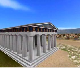
Fig. 1 - An image from "A walk through Ancient Agora."
Museum of the Agora seems to me to be a reasonable, if very short, introduction to the collection, but the "illustrations" at the foot of the page are only bibliographic references to the images. Oddly, one of the basic bits of information available at the Agora web site () is missing: the open hours. In addition, the numerous illustrations available at the Agora web site (e.g., ascsa.net/research?q=accessionnumber%3A%22Slide%20Set%3A%2001%22&t=image&v=icons and ascsa.net/research?q=accessionnumber%3A%22Slide%20Set%3A%2002%22&t=image&v=icons) have not been utilized. (In fairness, the illustrations are called up by a search procedure, but that procedure and the fact that Agora Excavations personnel have been consulted for this site suggest that obtaining illustrations should have been possible.) So one wonders again why there is no link to the web site of the Agora.
History of the Excavation(s)2 is short and, once again, cries out for a link to the Agora web site.
Despite my concerns about the Description as indicative of an ill-defined audience, it seemed to me to suggest a self-conscious approach that is appropriate for such an effort. Indeed, I am always heartened when it seems that a project, such as this one, has grand hopes AND a clear understanding of the need to examine their own results in the end. In this case, the approach to the making of the computer models is particularly exemplary, being explicit and well-considered, with general information on the home page and more specific information about each model via the Versions and Concessions page.
The Versions and Concessions page leads to a page for each structure, and that page details the issues involved in making the computer model. In particular, the information is clear and explicit when there are different published views, stating whose views were followed and providing bibliographic references. This is exemplary and rare; the site's producers should be commended for being so specific about the modeling.
I would have liked more images from the models, showing models partially complete, perhaps the remaining portions only, or multiple images with different lighting, but those are quibbles when the processes have been so clearly laid out. It is unfortunate, though, that the images are so as to yield minimal information.
I have admittedly rushed through the items just listed to reach the portions of the site that are more truly about the Agora structures. It is these more information-laden parts of the site that should make it useful, whether to so diverse an audience as desired or a more confined one. So now to the meat of the matter.
1. Map of the Agora. At first blush the maps are very disappointing because there are no labels. However, the labels pop up when one rolls the cursor over any of the monuments shown; as a result the maps (actually a map only of the archaic period; the others - Classical, Hellenstic, and Roman are 3D renderings) are quite useful, though the labels are occasionally in Greek rather than English.
The technology used for the maps presents a very interesting example of using new, cutting-edge technology when older, simpler technology would not only suffice but do the job better. In this instance, the use of roll-over labels seems a good idea at first blush, but it has been accomplished with a plug-in that may or may not always work when a simple image would do the job better. (The Adobe Shockwave file in question did not work with my version of Safari, despite my having the required plugin, but did with my version of FireFox.) More important, using labels that pop up only on rolling the cursor over the requisite item on a map is simply not the best approach. First, it makes finding a given building a fairly random act unless one already knows which building is which. Second, it means that only one building can be labeled at a time. A good, old-fashioned map, on the other hand, shows its labels at all times. A rendering could also have standard labels. In either case, the user would be better served by an image with normal labels than the popup labels actually supplied.
Unfortunately, the structures shown on the maps/renderings have not been coordinated with the structures listed on the History - Archaeology pages (see below for the discussion of those pages). The map of the archaic Agora, for example, does not include buildings C, D, and F, which are treated as a group in the list of buildings in the archaic Agora. Since these buildings were under the Old Bouleuterion, putting them on the map would not have been easy, once again suggesting that a more standard map would have been better, since a more standard map could easily have shown the earlier structures in a different color and with a color-coded label. They would not have been competing for the roll-over action on a standard map.
The Classical period view of the Agora includes the Old Bouleuterion, but the list of buildings does not, presumably because the building was erected in the prior period. However, unless there is explanatory text on the site that I have missed, the building should have been included on the list of Classical period structures either in a second list of survivals or without comment, leaving the description to cover the complications. Similar problems exist for the later periods.
The map-compared-to-building-list problem is at least recognized in the case of the Square Peristyle, a structure thought to have stood between roughly 300 B.C. and about 150 years later. A VR model of the building was created, "though it does not belong to any of the phases of the project (Classical, Hellenistic and Roman)." (See project.athens-agora.gr/index.php?view=ekdpar&pid=28&lang_id=en -- last accessed 12/18/09.) It is difficult for me to understand how the building is conceived in this way, but, in fact, it does not appear on any map.
2. History - Archaeology There is an enormous amount of material in this section, which has a subsection for the following periods: Neolithic, Bronze Age, Geometric, Archaic, Classical, Hellenistic, Roman, Medieval, and Modern. For each period there is a general introduction with some topographic information, and there are sub-sections about finds (for all periods) and buildings (for Archaic through Roman). The sub-sections about buildings consist of a list of the buildings of the period in the Agora, and each building name is a link to a page with information about that building -- the kind of page I found via Google Earth to lead me to the site.
It is difficult to summarize, but I will try to do that by treating separately the historical outlines, the finds, and the descriptions of the individual monuments.
Historical outlines: The discussion of the Neolithic period seems short but pointed and useful, especially in pointing out the growth of settlements on the south side of the Acropolis rather than in the Agora area. However, the language is not as clear as it should be, and the absence of a map indicating the locations of the mentioned wells is frustrating, especially in a resource that seems to be so multi-faceted.
For the following period, the Bronze Age, the absence of a well-defined audience is more problematic. The use of "LH I" and similar abbreviations, to be sure virtually always with dates as well, makes the reading difficult for less knowledgeable readers and tedious for the experienced. Add to that, once again, the absence of a map that might, for instance, show the location of the Areopagus, once again damages the presentation.
The material concerning the archaic period is even more frustrating because it is at one and the same moment very rich and very unfocused. Undefined terms that would stump a non-specialist abound -- e.g., Peisistratidae, Alcmaeonid, expulsion of the tyrants, thalassocracy, diachronically -- and too litte is directly about the Agora. The final paragraph, which is a commendable attempt to include very recent scholarship, can only be incomprehensible to a non-specialist. Once again, the absence of a map is unfortunate, and in this instance bibliographic references should also have been present.
The discussion of the Classical period is far more confined to the Agora and the structures in it, not the history of the city (with the exception of the first paragraph about the Acropolis, which seems completely unnecessary), but the many structures erected in this period again cry out for a map. Unfortunately, the discussion of the Hellenistic period reverses matters, being mostly about the general history of Athens. The Roman period is a middle ground, with much straight history but also a good bit of information about the buildings in the Agora. The Medieval section is more straight-forward, though the undefined "raid of the Heruli in 267" is another case of the problem of an ill-defined audience. The Modern period is covered in a summary fashion that seemed surprisingly short.
In general, these sections are both interesting and frustrating. The absence of maps, references, and focus is consistent, but the content is often generous and sophisticated.
Despite all the information in the Credits page, it is not possible to determine who is responsible for content of any specific page. In the case of such a complex site, this is not surprising, but it is problematic. Reading about Mycenaean Athens, for instance, a specialist might well wonder about some of the more casual general statements (especially those that are internally inconsistent), but a general reader would be inclined to accept them uncritically, leading to confusion. Were there a named author, there might be a way for the casual reader to approach the material more carefully or for a scholar to suggest improvements. To be fair, suggestions would be uncommon, but they will be non-existent, one suspects, if there is no individual to whom one might address a comment.
The "Findings" section for each period is unexpectedly broad - not just a list of objects but a discussion of the kinds of objects and more, including the rise and fall of the Athenian economy. Unfortunately, there are no images and only references to lead to images (in books, not online) at the end of each discussion. The earlier periods -- when the Agora was less exclusively an administrative area -- provide better discussions because the authors have been less limited to discussing the monuments. Much of the discussion in those earlier periods especially regards pottery, and the lack of illustrations is especially distressing for pottery since so many shapes are named yet are not common, household terms. (Oddly, the plurals for the pottery shapes are often not used when they should be in the English, though the Greek version does use plurals.)
For each period from the Archaic through the Roman there is a list of buildings. In each case, the list is only a list, but each entry leads to a page with serious information. The lists are unfortunately not coordinated with the maps, as noted above.
Thankfully, given the seeming ad hoc comments in the popup windows on the Google Earth presentation, the building descriptions are more consistent. Most begin with the location, date of construction, and periods of use -- but not a map, of course. (It is an unfortunately common difficulty with presentations like this that authors are unwilling to say "unclear" or "uncertain" or something even more useful when there is an absence of information. There is, after all, a difference between no information and the directly stated absence of clear information, ambiguity, or confusion.) On the down side, buildings are included in the list for a given period only if they were built during that period. Thus, for instance, the Stoa Basileios is included only in the list of buildings of the classical period, although the discussion includes the later history of the structure. Since it would be a simple matter to color-code the names of monuments constructed during the period in question or to otherwise make a clear distinction, this seems truly unfortunate.
There follows an introduction and then period-by-period discussion (or a single description when there is only one period involved), and a bibliography. The organization one begins to expect, though, is often missing. To make matters worse, the first period discussed may or may not be the one in which the building is actually listed; the Temple of Zeus Phratrios and Athena Phratria, for instance, is said to be a classical building, but the first period mentioned after the introduction (where the date is restated) is the Hellenistic. All the buildings of the archaic period save buildings C, D, and F (treated as a group) have the classical period as the first period of discussion. Buildings C, D, and F have a description but no period-by-period discussion.
These building-by-building pages are the strongest parts of the web site. There is an enormous amount of information in them. Indeed, one of these pages first drew me into the site. It is unfortunate that the sure hand of a good editor is so clearly in absence. A good editor might have introduced some consistency and corrected some of the obvious errors already mentioned here.
The information on these building-by-building pages is remarkably full and complete, and there is a good bibliography at the bottom of each page, just before renderings of the buildings. (However, there are no footnotes; so linkage of individual facts to specific authors is missing.) Missing are drawings and photographs that might make some of the text more clear. While the renderings show the restored structure, they do not let the reader see what was found as opposed to what has been restored. Drawings in particular would be valuable to help readers decipher what can be rather dense prose descriptions. (For instance: "Of the first phase, the crepidoma, its so-called lower crepidoma, measuring 9.35 (E-W) x 9.85m (N-S) survives in a – comparatively – exceptional condition in the excavated parts – only two blocks are missing. It comprises large soft yellow poros blocks, joined without the use of clamps. Their size varies, ranging between 0.33-0.40m in height, 1.30-1.80m in length and 0.45-0.465m in width. Part of the crepidoma rests on the bedrock and part on the ground." from the page concerning the Altar of the Twelve Gods at http://project.athens-agora.gr/index.php?view=ktirio&pid=3&lang_id=en, 1/5/10)
There is also the ever-present problem of the ill-defined audience. As that passage indicates, there is detail here for the expert, but the scholar will go to the publications. It is the interested non-specialist who can be expected to come to a site like this (at least for now and for some time to come), but the descriptions are too often inappropriate for such an audience. The necessary drawings and photographs that could show more than an imagined structure, an overview of the structure, less pretentious language, and more careful descriptions would all have helped enormously.
The renderings at the bottom of each building's page are among the important contributions of the Foundation of the Hellenic World; however, they are very small. In addition, they suffer from the usual problems of renderings, as already discussed above.
While attempting to examine the site for this review, one interesting anomaly became apparent, and it seems worth noting because it could present a problem with any large web site. All the web pages about buildings in the Agora use the same title. As a consequence, every window or tab has the same title. This makes navigating among a large number of open pages all but impossible, and it required that I take some time to figure out how best to display the various windows and tabs. This is certainly a convenience for the builder of the site, but it's not convenient for the reader.
The stated hope of the designers of this web site -- to use it as a starting point, not an end -- suggests that this web site can become what they have wanted, a superb blending of information and technology. But it remains to be seen whether or not the authors will work to improve a good beginning so as to create something of real lasting value. Doing so will not be easy because so much has been done that starts from what I find a dangerous premise: that a single site can be made to serve the needs of such a diverse audience without making it far more complex. In my view, that is that critical point; to make this web site into a paradigm its designers must decide how to reach individual portions of that large audience and then determine how to meld the pieces into a coherent and useful whole. There is so much of value that it would be shame to leave this site unimproved.
-- Harrison Eiteljorg, II
1. Files using the KML format are used to "display geographic data in an Earth browser such a Google Earth" code.google.com/apis/kml/documentation/kml_tut.html (last accessed 01/31/10). The file format is based upon the XML standard. Return to text.
2. The parenthesized s in excavations notes that in one place the term has the s and in another not. This is a trivial matter, but it reflects a level of editing that is in evidence again and again in the English text. In many instances the problems seem to be faulty translations but in others just sloppiness. In a site as large is this one, such problems are to be expected, but the site has been online too long -- judging by the 2006 copyright date on virtually all pages -- for so many errors to remain uncorrected. Return to text.
For an index of other CD and Web site reviews available from the CSA Newsletter, see the review index.
An index by subject for all CSA Newsletter issues may be found at csanet.org/newsletter/nlxref.html.
Next Article: Cloudy Skies?
Table of Contents for the January, 2010, issue of the CSA Newsletter (Vol. XXII, No. 3)
 Table of Contents for all CSA Newsletter issues on the Web
| CSA Home Page |