
|
AutoCAD Release 14 has been out for nearly a year, and I have now been working with it for a few months. During that time, I have not tried to run specific tests to compare it to the previous release, but I have made an attempt to assess the new version. In general, the assessment is very positive. Release 14 represents a large step forward, if not a radical one.
There are specific features in Release 14 that are noteworthy: new polylines, smaller files that open more quickly, a new entity called a region (not new to Release 14 but not previously discussed here), an improved way to deal with raster images, impressive renderings, and some handy new interface features. There are also a few negatives: continued confusing and pointless terminology for attaching databases, yet another revision of the DWG file format, and new complications with DXF files.
AutoCAD still needs two basic changes to its standard operations: specifically, the ability to deal with more than one model at a time and simultaneous, multiple, resizable, independent views of the model. It is possible to run multiple iterations of AutoCAD to work on multiple models, but that eats up a great deal of memory when compared with one iteration of the program and two or more open models. It is also possible to have multiple views of the model on screen, but they must exist in a single window, and the only way to have different layers on display in each view is cumbersome in the extreme. It may be difficult to deal with both of these issues at once, and I would prefer to see Autodesk concentrate on providing multiple, independent views of a single model as the first priority. This is one area where Microstation 95tm is definitely superior.
I should note that I have not tried to include all new features in this review. Instead, I have concentrated on things I found interesting, useful, or noteworthy.
Polylines. AutoCAD's term for a single line consisting of multiple segments is polyline. A polyline may consist of any number of line segments, and they may be straight or curved, on a single plane or wandering in three-dimensional space. In previous versions of AutoCAD, all two-dimensional (planar) polylines had the same storage format, requiring a good deal of wasted space. Now there are simple and complex polylines, and the simple ones can be stored much more compactly. There is also a new and better way to store hatching information in the files. The result of these and other changes is smaller files and files that open more quickly. (I found that the older propylon model lost about 25% of its bulk when transferred to Release 14.)
Regions. Regions were introduced in Release 13, but I did not comment on them in the review (IX, 2; Aug., 1996, pp. 10-11). Indeed, I said some things that were off the mark because I had not realized the utility of this command. It can be very helpful.
It has always been cumbersome to make complex, truly irregular surfaces with AutoCAD. (Cumbersome, but possible. Some complex surfaces simply cannot be made with other programs.) Using the region command greatly simplifies the making of very complex surface shapes - so long as they are two-dimensional, planar surfaces. Surfaces that took huge quantities of time and enormous patience (I think here particularly of some of the surfaces in the Pompeii forum model that we surveyed with the single-photo photogrammetry system) can be created in a small fraction of the time previously required.
Complex regions may be made by combining regions or subtracting one from another with relative ease. In addition, splines - smooth, curved lines - can be used to define the boundaries of regions; so it is possible to make surfaces with smooth edges, even when there are no simple mathematical expressions for the shapes of those edges. For these surfaces bounded by polylines, however, there is a trade-off. When AutoCAD makes a region from a spline (or a polyline with fitted curves), the original spline or polyline is deleted. So are the points that defined the original shape. As a result, access to the coordinates of those points is also lost. For scholarly purposes (and many others, I would suspect) it is thus necessary to make a copy of the original spline or polyline before making the region from it; the original data points can be preserved in the copy and retained in the model. Despite that slight problem, this is a very useful feature.
Raster Images. In prior versions of AutoCAD, raster images could be brought into the drawing; the images became part of the file. In Release 14, raster images are not made part of the file; instead, only references to the images are placed in the file. An included image is displayed as if it were a part of the file, and the difference in utility is nil. The raster images can still be scaled, moved, and rotated, but AutoCAD only contains information about the files and the processes, not the files themselves. As a result, new DWG files with imported raster images are much smaller.
We used this feature to good effect to compare two maps of the north slope of the Acropolis. The two maps were brought into an AutoCAD model, and one was rotated, moved, and scaled so that it directly overlay the other. Not only could we tell clearly how the maps were alike and different, the resulting file was only 26K in size, because the images were not actually stored in the file. (The original image files were more than 300K in total size.)
Renderings. I've not often used the built-in rendering of AutoCAD before, but I have used that feature in Release 14, and I am very impressed. I was able to use my own photographs to provide the surfaces for specific blocks, and, with those photos, to create very good renderings (see Fig. 1 for an example, one that looks a great deal better in color on a monitor than in the black-and-white reproduction on paper).
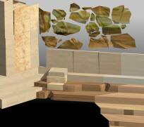 AutoCAD R14 rendering of in-situ remains of the
older propylon (plus now-missing extensions of steps and revetment
blocks, which have lighter tones than the in-situ portions to make clear the distinction).
The bedrock in the foreground (black area) has not been modeled; so the area was left
black. The Mycenaean wall blocks (only the ones surveyed are included) were modified
slightly with PhotoShop® to make the surfaces seem more natural.
AutoCAD R14 rendering of in-situ remains of the
older propylon (plus now-missing extensions of steps and revetment
blocks, which have lighter tones than the in-situ portions to make clear the distinction).
The bedrock in the foreground (black area) has not been modeled; so the area was left
black. The Mycenaean wall blocks (only the ones surveyed are included) were modified
slightly with PhotoShop® to make the surfaces seem more natural. The system even calculates cast shadows, making renderings seem very real indeed. Used in conjunction with WalkThroughtm, Autodesk's inexpensive virtual reality package, the renderings are especially helpful. A few renderings provide a good sense of the real appearance of the model, and then WalkThrough, with its much lower quality renderings, shows changes in perception when standing in different places or moving through the space. The combination of the two programs is, I think, quite powerful.
New Interface Features. Among the most valuable of the new interface features is what is called "real-time pan and zoom." Using the pan or the zoom command, you can move around the model or zoom in and out much more quickly and easily than in the past.
Release 14 also provides a greatly improved way to use existing points in a model when constructing new entities. It has long been possible to instruct the system to "snap" to an existing point in a model (the end of a line or the center of a circle, for instance), but it is now easier, faster, and more secure. (A related and equally important feature - more important for my own usage - allows users to set the system so that coordinates entered from the keyboard will always over-ride the object snap choice, even when the new coordinates are very near a snap point. This corrects a problem of long standing. (Indeed, a warning about using the object snap feature is included in the AutoCAD tutorial on the CSA Web site, http://www.csanet.org/inftech/tutorial.html because of that now-corrected problem.)
Miscellany. Release 14 also brings full editing control to the command line (the keyboard entry area that permits execution of typed commands). Commands can be cut, pasted, and edited; so users can be more efficient with typed instructions. Of course, most new users will tend to use the icons rather than the command line; that's an unfortunate consequence of the dominance of the graphical user interface, since the command line in AutoCAD is so much more efficient than icons.
There are some other new commands that are quite handy. It is now possible, for instance, to change the current layer (the layer on which new objects will be drawn) by simply selecting an icon and then an object on the layer you want to use. Properties can be changed more easily, and any number of objects can be moved to a common new layer with a simple command.
I especially liked some of the bonus features for manipulating layers. These were included in the bonus package (but not in the documentation); so users may not find them if they don't install the bonus items - as I did not on the CSA laptop when I first installed Release 14 there. One of those bonus features let me quickly and easily select objects and move them to the current layer; another let me move one object to the layer of another using only the mouse (saving me from needing to know and type the names of layers), and another quickly isolates the current layer by turning all others off.
Another of the bonus features will be very useful for those who do not use a layer-naming scheme. As many readers know, CSA has long advocated a system for naming layers that permits layers to be manipulated according to characteristics, not names. Using a good naming scheme, I do not need to remember the names of layers, only the scheme; I can access them according to characteristics I care about (e.g., material, use, date, etc.). Autodesk has provided a feature that is nearly as useful. If you have a view of the drawing with layers on and visible in a useful combination, you can save that layer configuration, give it a name, and recall it at any time. New layers, of course, would be left out of such a system, and only layer configurations previously saved by a user could be accessed. Nonetheless, this should be a useful feature for many.
One last feature is worth mentioning. The right mouse button functions as the carriage return, meaning that a command can be repeated by simply choosing the right mouse button.
DXF files. DXF files are files for exchanging CAD information between and among programs, and the DXF format has become the de facto standard for transferring data from one system to another. Despite that, DXF files can no longer be directly imported into an AutoCAD model. They can only be imported into an empty file. Now, you must import the DXF file into a new drawing file, save that drawing file as a DWG file, and then import the DWG file into an existing model. Since Autodesk controls both the DXF format and the AutoCAD program, this cumbersome operation seems unfortunate and unnecessary.
DWG file format. I have already mentioned the revised file format. The new entities - simpler polylines, new hatching, and new raster image support, for instance - require a new DWG file definition, but the extensible DWG format is still not the kind of file format we need. This was brought home forcefully to me when I first opened the older propylon model in Release 14. A dialog box popped up explaining that there were entities in the drawing for which the necessary program was not present. So far as I could determine, the entities in question were the ones I had entered with AutoSurf and then removed after realizing that they were not supported by AutoCAD (see "Review of AutoSurf - Plus Some Ruminations about File Formats for Scholars" and "A Problem with AutoCAD Files"). Despite the fact that the entities had been removed, the program saw some kind of remainder and flashed a warning. I was able to fix the problem (with advice from the AutoCAD Users Group), but it emphasized again the problem of the DWG file format. It is not a standard that we can rely upon for long-term storage because it is too flexible. That's rather ironic, but the format is so flexible that there is no true standard.
At least a problem message appeared when the file was opened in Release 14.
Database connection. My final criticism regards the database connection. I've become more used to the system and its arcane vocabulary, but it remains cumbersome and needlessly obscure. At a recent demonstration I was caught with the database files not properly connected to the older propylon model (because of a re-installation of Windows NT on the laptop). Although I knew in general how to remedy the situation, the arcane vocabulary left me unable to make the correct changes, and the demonstration (not to mention the demonstrator) suffered as a result.
Remaining problems aside, Release 14 is definitely a large stride forward. It is faster, seems more stable, and has a good many new features of value. It is a significant improvement.
-- Harrison Eiteljorg, II
To send comments or questions to the author, please see our email contacts page.
For other Newsletter articles concerning the applications of CAD modelling in archaeology and architectural history
Next Article: Software Gift from Autodesk
Table of Contents for the Winter, 1998 issue of the CSA Newsletter (Vol. X, no. 3)
 Table of Contents for all CSA Newsletter issues on the Web