 |
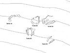
More work has been done on the cemetery at Pseira. All the built tombs have been modeled, and two-meter contour lines have been brought into the model as well. It is now possible to combine the tombs and the contours to create an overall map, such as Fig. 1 here, or to make a more detailed view of a particular section where there seems to be a grouping of tombs, as shown in Fig. 2.
 |
 | |||||
| Fig. 1 - The cemetery at Pseira, | Fig. 2 - Detail of Pseira Cemetery | |||||
| with all built tombs, two meter | Tombs 3, 4, 5, 6, and 16 from Fig. 1. | |||||
| contours, and coast line. | | |
| |
Meanwhile, data for a surface survey of the area around the cemetery have been put into a database format and will be attached to the survey grid in the model. More work is also being done on the architecture at Pseira.
Additional information for the model will be collected this summer when Professor Betancourt and the rest of the staff return to Crete.
Other CSA Newsletter articles on Pseira:
Pseira CAD Work Continues (Vol. 7.4: Feb. 1995)
New CAD Work on Pseira Cemetery (Vol. 7.3: Nov. 1994)
For other Newsletter articles concerning the applications of CAD modelling in archaeology and architectural history, consult the Subject index.
Next Article: Publishing with Computers
Table of Contents for the May, 1995 issue of the CSA Newsletter (Vol. 8, no. 1)
 Table of Contents for all CSA Newsletter issues on the Web