
| Vol. XXVI, No. 3 — January, 2014 |
Articles in Vol. XXVI, No. 3
The Levantine Ceramics Project
Further exploration of the potential for collaboration.
-- Andrea M. Berlin
Archäologische Informationen in Open Access: A model case for changes in academic publishing
Moving online requires careful planning.
-- Frank Siegmund
Editor, Archäologische Informationen
Website Review: Israel Antiquities Authority: Archaeological Survey of Israel
A model website for a country's archaeological patrimony.
-- Andrea Vianello
Technophobia and Technophilia
Technology should not be feared or uncritically adopted.
-- Harrison Eiteljorg, II
Miscellaneous News Items
An irregular feature.
To comment on an article, please email
the editor using editor as the user-
name, csanet.org as the domain-name,
and the standard user@domain format.
Index of Web site and CD reviews from the Newsletter.
Limited subject index for Newsletter articles.
Direct links for articles concerning:
- the ADAP and digital archiving
- CAD modeling in archaeology and architectural history
- GIS in archaeology and architectural history
- the CSA archives
- electronic publishing
- use and design of databases
- the "CSA CAD Layer Naming Convention"
- Pompeii
- pottery profiles and capacity calculations
- The CSA Propylaea Project
- CSA/ADAP projects
- electronic media in the humanities
- Linux on the desktop
Search all newsletter articles.
(Using Google® advanced search
page with CSA Newsletter limit
already set.)
Website Review: Israel Antiquities Authority: Archaeological Survey of Israel
Andrea Vianello
(See email contacts page for the author's email address.)
Israel Antiquities Authority: Archaeological Survey of Israel
- URL: www.antiquities.org.il/modules_eng.asp?Module_id=47
- Authorship: Project managers are Yuval Baruch and Liat Ayzencot under the supervision of Dr. Uzi Dahari. Web Developer is EagleShade Interactive Production House. Individual authors are responsible for each brief published.
- Site host: Israel Antiquities Authority.
- Peer review: None stated.
- Permanence: No explicit information, but it has been available for some time. It is funded by the state of Israel.
- Archival procedures: None stated for the website, but all contents are also printed (excluding updates).
- Languages: Hebrew and English (only English section reviewed), some Arabic
Preface
Israel is a place with a long history, and there are about 25,000 known archaeological sites in the country, all densely packed in a relatively small area. Many sites encompass several periods and can present very complex stratigraphies. Other sites are "hidden" beneath constructions. The interest for ancient Israel is also very intense due to many locations playing important roles in the great monotheistic religions: Christianity, Judaism, and Islam. Israeli archaeology is similar to Classical archaeology because memory of the past never waned and several ancient texts — especially those forming the Bible — provide information usually not available to archaeologists in any other way than via excavations. The compactness of the territory and broad interest make this area an ideal candidate for a comprehensive survey of antiquities on a scale that could not be attempted anywhere else with such limited existing resources. The website reviewed is the digital output of just such effort and accounts reports for about a fourth of the total sites known. Of course, the website is constantly being expanded to meet, at some point in the future, the comprehensiveness suggested by its systematic design. Due to the magnitude of the survey, its constant updates, and the variable detail of the reports, it would be foolish to attempt the same detailed coverage reserved for reviews of other websites: just a list of the 25,000 sites planned to be included would exceed the space of a reasonable review. Thus, I shall review a tiny sample of what is published in order to assess its methodological validity and the effectiveness of the design. Before beginning, it should be considered that the survey itself is part of the Israel Antiquities Authority website, where further information on many excavations is published.
The Israel Antiquities Authority website
In addition to the survey, the website includes some introductory pages to the archaeology of Israel by period with brief mention of several key sites. In section Education materials from recent temporary exhibitions are archived in the form of short illustrated articles and multimedia presentations, largely PowerPoint-based. Further articles, better illustrated and longer, are found in section National Treasures, which presents permanent exhibitions. The Gallery of Sites and Finds includes a few very short articles organised by geographic location, presenting essential information on the key sites. Section Articles contains several short articles largely organised by period. Here there is some emphasis on interpretation and methods. An interactive plan was planned at the time of review, with a section on Movies presenting streamed videos from the Hebrew section, with English subtitles. The quality is variable, and the videos are too often of low quality in terms of the actual video imagery. Pages on events and a search form are also available. The graphic of the English section is dated but still effective. The Hebrew section contains extra contents only relevant to local residents. There is also a shorter version of the website available in Arabic. Overall, the contents are of limited value for experienced researchers, but are a welcome introduction to Israeli archaeology for the general public and students. Certainly they help in identifying key sites that can then be explored in greater detail in the survey pages.
The Archaeological Survey of Israel
The "Archaeological Survey of Israel" was begun in 1964 as work for a print publication. Survey maps covering an area of 10 x 10 km, on a scale of 1:20,000, were to provide the base data. The sites on the map are presented separately, in geographical order from north to south, and from west to east. The original publications are in Hebrew only.
The survey website welcomes visitors announcing that it is a "beta" version, using a geeky term. In fact, its incomplete status is clear, and it is expected to change as it grows. The welcome message also recommends the use of Chrome as browser, though there is no minimum requirements specified. The website works correctly with the browsers I tried: the latest versions of Chrome (32), Firefox (26), and Internet Explorer (11). The website is data-heavy and requires a relatively powerful computer with sufficient memory and a good broadband Internet connection, and the navigation of the website would be extremely difficult on mobile devices, but then such devices are not meant for extended reading of complex reports and the use of interactive maps. This is a website for the knowledgeable researcher, the advanced student, or the amateur archaeologist with some prior understanding and genuine interest.
The home page is very simple, split in half: on the left textual information, with a very limited list of archaeological sites, and on the right a map of Israel covered by clickable numbered squares representing mapped areas. Clicking on either the numbered squares or the list gives access to the same pages; indeed, the listed sites have next to them the corresponding number. The navigation bar on the top of the left side can be ignored as it serves no purpose in its present state. One may zoom in and out on the maps, and the site uses software resources by the Open Source Geospatial Foundation, which is a better choice than any commercial mapping services such as Google or Bing for reliability, control, and future availability. (It may not be an effective choice for smaller websites due to the complexity of its implementation, but for larger scientific websites an open source mapping software solution should be a requirement today.) The map is very responsive and can be zoomed or dragged as required. Geographic detail is limited, but more would be unnecessary and only add to the complexity.
A problem encountered consistently with all browsers is that clicking on the map often does not load the corresponding left panel with information about the area represented in the map. This is not a coding defect; no information is available for that square. Thus, the fastest way to access the active squares is to look at the list on the left. This forgivable quirk will not deter serious readers, who know from the onset that the survey is largely incomplete. I can understand that implementing placeholder pages can add to the complexity of maintenance and it could cause problems if contents were added and the placeholder pages not removed; however, a better design would include a placeholder that is automatically replaced or removed when information is added. Clicking on any square with information or one of the sites listed opens the contents on the left side, adding just a green marker to the corresponding square of the map. The pages, despite being split, do not use frames; so the two sides of the screen appear to be independent pages. It is not possible to resize or hide the map, which seems to take much of the screen space. In fact, it uses a fixed pixel resolution for the left panel, which results in the left panel always appearing consistent in size but covering an increasingly smaller portion of the screen, especially modern widescreens. Allowing manual resizing of the two columns would be a major improvement recommended for the website. I shall concentrate on the contents of the left side from here on.
The Left Panel contents
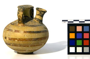
When one of the active hyperlinks triggers contents on the left panel, the panel displays a brief, illustrated article summarising the archaeology of the area, and at least another tab appears, sites, listing all the archaeological sites in that square. For each site, there is a hyperlink to a full article. Many sites are split by excavation or period, so that the actual number of sites is lower than the official count. The articles are often published reports specifically prepared for the survey. There are some credits, but these are irregular. For instance, for the site of Gazit (46) the name of the person that adapted (and perhaps translated the text in this case) appears, but the name of the author is missing. It is simply unacceptable to omit the name(s) of the author(s). Clicking on sites and then any of the listed sites opens a further tab, with the name of the site. There, basic details are provided, which usually include a short description and a bibliography. Further clicks on the sites tab opens more tabs, one for each clicked site name. It should be noted that some sites only have a number, not even a name, and lack the most basic description: some "sites" are in fact isolated structures, such as water cistern 618 on square Gazit 46. This level of detail is very welcome since all sites have a precise location. (I would not recommend publishing on the Internet the exact location of all archaeological sites and features in most cases, because of fear of looting or damaging. This may work in Israel where there is a high level of security in place across its territory and an active connection between antiquities and religion, but it would certainly present risks to the heritage in most other situations.) Some sites have a few illustrations following the articles, and the pictures sometimes are B&W, sometimes colour. Architectural or natural features of the sites, finds and sometimes plans of sites are the typical fare of the pictures. In general, there are only a few, usually two or three for each site, but interestingly many minor sites have pictures.
The coverage of the mapped areas is patchy, but there is a higher number of coastal areas available. Since the online survey at this stage is catching up with the printed publication, which is also far from being complete, one has to be content that the contents are freely available online, translated into English, and mapped. The alternative is to look for specialised publications that are hard to find but in a few libraries. There is some concern about how updated the information is, but my sampling test has yielded very positive results. For instance, I noted that the textual description of Tel Kabri, a major Bronze Age site, mentions and discusses the recently found frescoes, and there is evidence that online reports as well as recent bibliography are being added, albeit with some delay. In short, the descriptions may not be aware of the very latest reports, or use the most updated sources, but given the scale of the project, they get very close, more than expected.
There is of course high variability in how each mapped area is covered. For example, square 72 is published without a single site being named or any general introduction as in other briefs. It is still better than a blank. Other briefs reach significant depth in their presentation of the evidence, effectively discussing the territory in great detail. In some cases (e.g. Ashkelon 87; Ashdod 84) single sites split by period or excavation represent a significant portion of the sites listed for that mapping square, and all multiple entries could be better integrated, but this is more a suggestion for the future than an actual criticism. It is a matter of fact that the squares are outlined artificially; therefore, each contains a random portion of territory following no geographical or historical boundaries. In my sampling, I encountered almost empty squares, squares dominated by single sites, squares with multiple important sites, or squares with only minor features. Some mapping squares are marked as in progress, which is encouraging because it is further evidence that the website is being updated. It is generally very easy to recognise the most recently updated briefs thanks to the use of colour pictures, but I stress that many updates seem to have been added after the printed publication. (Why is it that so few websites routinely date all content, something that seems so natural for scholarship?)
All pictures can be enlarged for printing, there would be also some buttons for the operation that open a popup, but they seem broken. (They work but are almost invisible.) Some recent pictures can be enlarged through JavaScript by clicking on them, without opening a popup window.
The irregular numbering of the squares (e.g. there are 11 squares numbered 109, each with an added number after a slash to recognise them) is proof that original plans are shifting. There are blanks (e.g. areas not numbered) too.
Conclusions
This is a very large project of great importance for researchers and anyone interested in Israeli antiquities. It is also a powerful tool that, once completed, will help with the managing of ancient heritage and perhaps even permit builders to check an area for antiquities before submitting a new application. Similar online projects have been produced by other countries. Greece, another country very rich in culture, has produced Odysseus (odysseus.culture.gr/a/map/emap.jsp), an interactive map listing the most important sites. It uses Google as the mapping base, however, and it is not nearly as detailed as to the maps or the textual information. It targets primarily tourists and amateur archaeologists. The Carta Archeologica d'Italia (Italian Archaeological Map) is a similar long-standing research project. However, the online version, forma italiae, uses a regional approach for its online output so that there seems to be no driving force to cover the entire country quickly. The printed version is slightly closer to the Israeli model, but it is an academic series not easily accessible and quite disconnected from local authorities (even those responsible for the conservation of the heritage) and the public. The closest existing match, when considering online resources, is Fasti Online (fastionline.org/), which is clearly centred on Italy, but has been expanded to other countries. The result is uneven, since information for each record is provided by individual institutions, and it is focusing on modern excavations rather than archaeological sites.
Ultimately, nothing comes very close to what has been achieved by the Israel Antiquities Authority. For this reason, the Israeli survey should serve as a model for many other countries, especially Egypt, Greece, and Italy, which have a similar density of important antiquities in their territories. Producing such databases (surveys) would be enormously beneficial for planning, tourism, and research. It is obviously a large task that requires many years, but with some coordination and perhaps some help from new Internet publishing technologies (e.g. permitting readers to add or link information, raise alarms when due, and facilitate access to the heritage to fellow visitors), the idea is a clear winner.
Despite shortcomings due to the project being incomplete, it is still years ahead of any other similar project that I am aware of. A detailed survey of the territory presents significant advantages, and it is clear to me that producing and publishing contents in parallel is the best solution, as it makes possible a single framework for several areas. Because some areas may already take advantage of the work, it also adds pressure for completing the blanks. The single framework also gives confidence that the project has an end in sight, and as far as that may be, it maintains pressure on the relevant authorities to keep the project alive.
In short, this website represents a model that ought to be replicated elsewhere, and that is already very useful despite having completed only one-fourth of its intended work.
-- Andrea Vianello
All articles in the CSA Newsletter are reviewed by the staff. All are published with no intention of future change(s) and are maintained at the CSA website. Changes (other than corrections of typos or similar errors) will rarely be made after publication. If any such change is made, it will be made so as to permit both the original text and the change to be determined.
Comments concerning articles are welcome, and comments, questions, concerns, and author responses will be published in separate commentary pages, as noted on the Newsletter home page.