
| Vol. XXIV, No. 2 | September, 2011 |
Articles in Vol. XXIV, No. 2
Project Publication on the Web — III
Organizing and planning the work.
-- Andrea Vianello, Intute, and Harrison Eiteljorg, II
Photofly from Autodesk - 3D from Photos
Experimental software for making 3D models.
-- Harrison Eiteljorg, II
Project Publication on the Web — IV
The final publications.
-- Andrea Vianello, Intute, and Harrison Eiteljorg, II
Website Review: The British Museum Ancient Civilization Sites for Young People
Superb introductions to ancient civilizations.
-- Phoebe A. Sheftel
Website Review: CyArk
Much potential and many problems.
-- Andrea Vianello
Miscellaneous News Items
An irregular feature.
To comment on an article, please email
the editor using editor as the user-
name, csanet.org as the domain-name,
and the standard user@domain format.
Index of Web site and CD reviews from the Newsletter.
Limited subject index for Newsletter articles.
Direct links for articles concerning:
- the ADAP and digital archiving
- CAD modeling in archaeology and architectural history
- GIS in archaeology and architectural history
- the CSA archives
- electronic publishing
- use and design of databases
- the "CSA CAD Layer Naming Convention"
- Pompeii
- pottery profiles and capacity calculations
- The CSA Propylaea Project
- CSA/ADAP projects
- electronic media in the humanities
- Linux on the desktop
Website Review: CyArk
Andrea Vianello
(See email contacts page for the author's email address.)
CyArk
- URL: http://archive.cyark.org/
- Authorship: No individual credits could be found other than a mention of founder Ben Kacyra, one of the two civil engineers who founded Cyrax, the company that first introduced portable 3D scanners.
- Site host: Hosting is provided by dedicated servers owned by specialist hosting company ZeroLag Communications, Inc.
- Peer review: None stated.
- Permanence: No explicit information; domain has been registered for a long term to 2020. The site aims at preserving digital data and therefore it is expected to have long-term storage plans.
- Archival procedures: The site acts as archival depository for digital data, but I could find no information about archival procedures.
- Languages: English and Spanish.
Background History
CyArk was founded in 2003 by the Kacyra Family Foundation, a 501(c) (3) charitable trust founded by Ben Kacyra, one of the co-founders of Cyrax. The website presents CyArk as "a non-profit entity whose mission is to preserve Cultural Heritage Sites through collecting, archiving and providing open access to data created by laser scanning, digital modeling, and other state-of-the-art technologies." CyArk became an independent non-profit organization in 2008. The "professional" version of CyArk has been available on the Web since 2006. (See below for a discussion of the differences between the professional and non-professional versions.)
The website reports that 28 laser scanning projects have been completed and archived in CyArk, with 46 further projects being in progress.Description of the Website
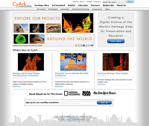
Fig. 1 – Screen shot of the home page. (Note that the screen shot does
not show all the interactivity provided by the sophisticated interface.)
The home page uses a simple composite interface made of parts. The logo on the top left reads, "CyArk Beta 4.0." CyArk frequently refreshes the layout of its website (now in its fourth major version) and adds new functionality through multimedia applications and new sections. I accessed the website for the first time in 2006, and I have encountered minor problems ever since (such as requests to install or update some plugin or scripts incompatible with my browser). Problems seem to arise from the need to insure plugin functionality and from the intense use of application programming interfaces (APIs) to make available services provided by third parties (e.g. Google® Maps and YouTube).
The "beta" status is not felt, thanks to widespread compatibility with several browsers (e.g. Chrome, Firefox, IE, Safari®, etc.), but the latest versions of browsers are recommended, as are disabling any filter that may interfere with scripts and providing full access to the computer for automatic installation of the latest versions of the required plugins. Since some functions depend on third party content or service providers, there may be unexpected outages.
Following the logo is a series of titles pointing to the main sections. The lower line lists and provides access to the sub-sections of any selected main section. On the upper right, a further menu provides access to login and registration facilities, language switching, and a search form. The search functionality is particularly sophisticated, and it highlights the keywords searched. (See Fig. 2.)
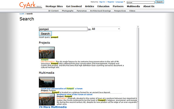
Fig. 2 – Screen shot of the search page for keyword search "Pompeii."
- Heritage Sites
- Get Involved
- Articles
- Education
- Partners
- Multimedia
- About Us
The main body of the home page presents a multimedia feature with interactive banners of highlighted information (such as the recent availability of the Spanish translation) and a button in a square box providing access to the archived data. Links to highlight recent news are also presented. At the time of writing of this review, the participation of staff members at international conferences appeared prominently. Links to mainstream mass media articles are presented as well, as is a system for subscribing to the newsletter. At the bottom of the page, a complete mailing address and contact details are provided, followed by a link to a copyright notice (where it is stated that some contents are licensed under a "Creative Commons 3.0 Attribution - Non-Commercial - No Derivatives" license). The very last line, in a small font, is a menu with further options, including a syndicated RSS service, basic FAQ page, the contact page (email form), and a useful site map.
Logging in is not required and does not provide additional menus, only access to additional contents (largely higher-quality multimedia contents that require fast data transfers).
Tests run with a smartphone (with the latest versions of UC, Opera Mini, and Bolt browsers) showed that the home page is not optimized for mobile viewing.
The layout of the home page is pleasant to see, but the menus and sub-menus should be re-organized in a more coherent way. Since a Creative Commons license is used, it may be a good idea to advertise it with a logo on the home page instead of a link to a separate page from the small text at the bottom. Although no data or multimedia feature is suitable for mobile viewing, the text pages should be mobile-friendly, especially for a site that embraces RSS, contains a blog, and advertises its presence in social media such as Twitter.
The FAQ page goes to some length to describe the many types of data available, but no page publishes the requirements to make use of the many interactive features. A technical section listing the requirements to access the website fully; links to download updated, required, free software; and a testing area for all plugins seem indispensable for such a technology-enhanced website.
The remainder of this review focuses on the "professional" version of CyArk for which registration is required. Registration is free, but it requires sending a signed document by fax or mail. The difference between the ordinary and professional versions was, as far as I could see, in the availability of better quality multimedia contents, a more sophisticated point-cloud reader, and some educational contents. Casual readers accessing the website out of curiosity will probably notice no differences, but anyone seriously interested in the data, for research or learning purposes, should register.
Section Map View presents a series of maps based on Google Maps, which provides the interactivity. Other views include lists of the sites being scanned by CyArk, and one requires the Google Earth plugin to work. A useful map of "Heritage At Risk" provides many sites known to be at risk. The list is incomplete however, and readers should treat it cautiously; Portuguese Oporto appears in the middle of the Atlantic Ocean (Fig. 3)!
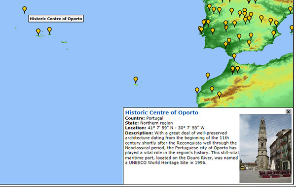
Figure 3 – Heritage At Risk: Oporto
I felt that this section was excessively based on Google Maps features, almost representing a technological showcase. The first four sub-sections are variants of the same list of sites, mapped, listed with or without images, and both mapped and listed with plugin required. Frankly, there is no need for Google Earth, or so many similar views. Readers should also note that the sub-menu in the form of tabs just below the "Heritage At Risk" title is redundant; the same choice can be found in the upper sub-menu, just below the logo. This is an unfortunate example of the inconsistency of the menus.
Section Get Involved asks for donations (surprisingly only through Google checkout), but also provides opportunities for volunteers and partners.
Section Articles contains links to the following informative pieces, in chronological order, which is confusing because none of them is what most users would call articles: entries in the blog, press releases, entries from the knowledgebase, some very short articles from news sources, and events. Each subcategory has its own RSS feed. Surprisingly, a large search form appears in the layout a few pixels below the standard search form, still visible (Fig. 4).
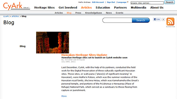
Fig. 4 – Blog page. Note the double search form.
This section, like the one on maps, seems an exercise in presenting the same information over and over. The RSS feed is needed only for the blog and perhaps the press releases. There is no need for a separate search form, and the introductory page with all types of information mixed should not exist: categories are there to facilitate finding information.
Section Education contains seven interdisciplinary K-12 lesson plans (accessible only after logging in; Fig. 5). These are divided between class activities and student projects. The lesson plans contain files in Word and PDF formats (same files available in multiple formats); a few pictures; and, in lessons 1 and 4, one PowerPoint presentation about Tikal (the same presentation for both lessons).
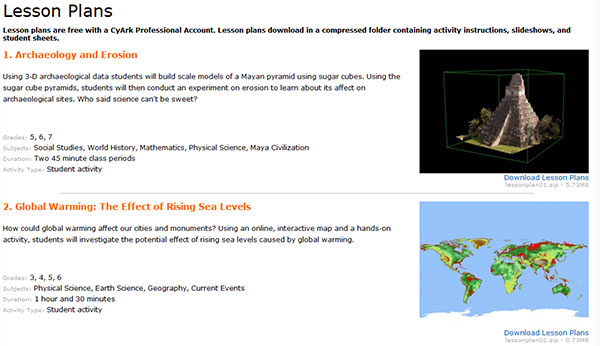
Fig. 5 - Screen Shot Lesson Plans
Two lesson plans require the use of Google Maps and, given the pace of innovation, may become outdated very fast. Whilst there is no harm in partnering with Google to establish a productive cooperation to develop some solutions (Google is listed as a partner), it is questionable that class activities should require and focus on specific commercial products, albeit currently distributed free of charge. There are some news items related to education as well, but this particular section has not been updated for two full years now.
Section Partners lists both partners and supporters, including universities and corporations.
Section Multimedia represents the core of CyArk, and it contained 5073 documents at the time of writing of this review, categorized as 3D Point Clouds; Artifacts; Documents; Drawings; Historic Drawings; Models; Panoramas; Perspectives; Photographs; Reconstructions; Time Comparisons; TruViews; and Videos. All documents can be accessed through this interface or from the web page of any historical site. It is possible to modify the listing of the multimedia contents using interactive controls. A double search form also appears on this section. Since multiple types of media are available for any one site, it is advisable to have a powerful and updated computer to access the website in the professional, high-quality mode. During my testing, my PC struggled at times to display some media while multi-tasking. (I used IE9, 32-bit, under Windows 7 x64 with a processor and GPU produced in 2008 and 4Gb of RAM without problems. I would expect that any recent browser is capable of displaying the website, but outdated software or smaller amounts of RAM may prevent its proper appearance or functionality.) Many multimedia features use QuickTime. Access to the 3D Point Cloud Viewer required downloading and executing a Java JNLP file, which then installed the necessary components and started the viewer. It is necessary to download a new JNLP file for each 3D model, but the installation of components is only executed if anything is missing. Java 7 x64 had no problems in running the 3D Point Cloud Viewer, but readers are warned that the viewer pushes hard on the processor and memory.
Process Explorer reported over 600Mb of RAM required for each opened model, with 1Gb of memory allocated altogether. The viewer over-stressed one of the cores of my microprocessor, whether I interacted with the model or not. The viewer itself is well designed, and includes most tools typical of 3D visualization programs to interact with the model. A reset button is available, and it is possible to use the mouse to interact with the model. The mouse wheel zooms in and out. It is possible to rotate, pan, and tilt the model with either the mouse or the keyboard (arrows). Since the 3D view is made of a 3D "cloud" of single point laser measurements (Figs. 6 and 7), some specific tools allow users to measure the distance between any such points. The models do not intend to be realistic as some CGI models, and they are very useful for study and learning purposes. A few models (see Fig. 7, top) have basic textures, which can, however, easily stress most computers and overwhelm some. The models also seem to apply some corrections in orbit mode that enable visualizing the model in a realistic way without it appearing tilted and with some minimalist object detection system that reacts, changing the zooming speed when crossing solid barriers. (Disclaimer: In 2007, after a shorter review of the website, I was asked for and provided feedback on the 3D Point Cloud Viewer while it was being developed. Some of my feedback may have affected the functionality of the viewer.)
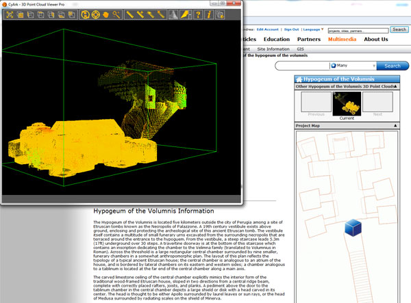
Fig. 6 – 3D Point Cloud Viewer within an independent window showing the cloud
model of the Hypogeum of the Volumnis. The web page from which the
viewer was started appears in the background.
Some 3D reconstructions, using the same 3D viewer or ordinary 2D pictures, allow some models to be analyzed for detail and composition rather than spatial layout.
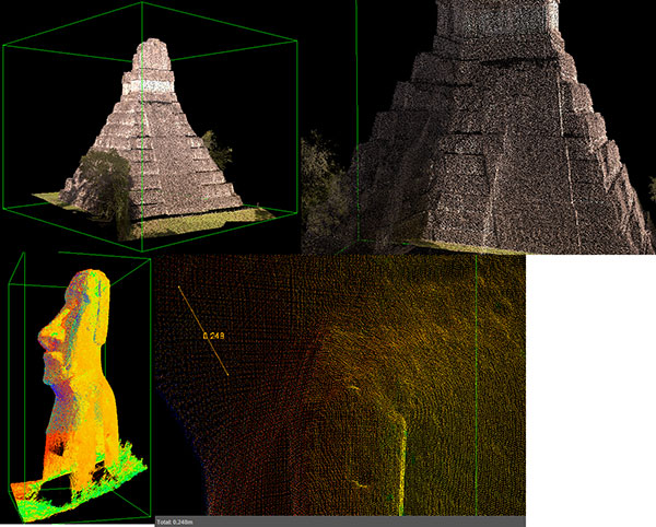
Fig. 7 – 3D Point Cloud Viewer. Top: 3D Chiché:n Itzá, and detail.
Bottom: Rapa Nui moai and detail with example of measurement.
There is no doubt that the 3D point cloud models are the highlight of this website. They allow users to perform substantial spatial analyses from the browser. The very few (only 5 at the time of writing of the review) Leica® Truview pictures are sophisticated composites of pictures that allow users to measure distances within the picture (Fig. 8). It should be stated that the Leica Truview plugin is currently available only for IE9 32-bit. This makes IE9 32-bit the only browser capable of accessing the whole CyArk website at the time of review. IE9 currently runs only on Windows 7. The linked (and current) version of the plugin caused serious instability issues in Windows 7 x64 and had to be uninstalled after the review.
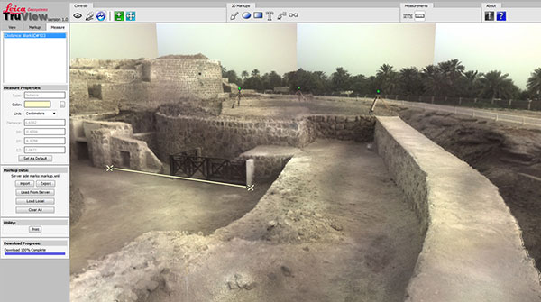
Fig. 8 – Leica Truview, image showing recording points (green dots)
and sample measurement. The accuracy could not be determined. The
software itself cast some doubts, suggesting that the model should be
updated on a newer version of the software for improved accuracy.
The About Us page contains short presentations of the project, with access to the contact page.
Despite this methodical overview of all sections of the website, most users should access the website by clicking on the View Sites link on the home page (which brings up the Map View of section Heritage Sites) and select an historical site to explore. For each site, numerous pictures and some videos are usually available. There is a short description available for each site. Most multimedia features also have useful, associated metadata. Despite all the material available at this website, short descriptions, pictures, and videos of cultural heritage sites do not provide solid presentations of such sites; nor will they be of much use to the specialist. At this point in time pictures and videos shot by tourists and specialists can be found at websites such as Flickr and YouTube. More detailed descriptions may be available in online publications, specialist websites, or online encyclopaedias. Websites such as Panoramio and Google Maps will also provide access to much free georeferenced data (mostly pictures) about historical sites. CyArk has been built around sets of geospatial data represented by the GIS plans (Fig. 9) and the 3D point cloud models (Fig. 6 and 7).
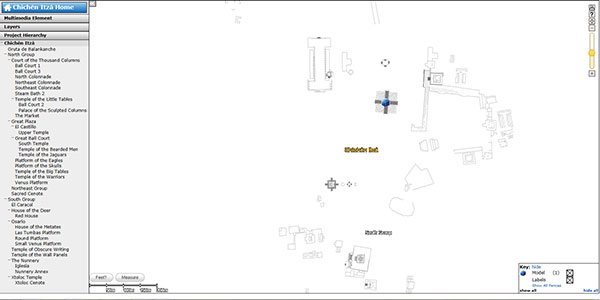
Figure 9 – GIS plan of Chichén Itzá.
Most other features, such as the architectural drawings, models, perspectives, reconstructions, Truviews, and videos are based on 3D point cloud data or GPS surveys. It is hoped that CyArk will continue expanding but also that the project will remain true to its origins and in the future concentrate on presenting as much data from laser scanning and GPS surveys across the world as possible. Additional multimedia features could be more easily made accessible by using additional websites, through APIs or partnerships. The use (and perhaps abuse) of Google Maps should be only the first of many such collaborations.
Conclusions
CyArk is a difficult website to classify. It aims to be a depository of data from its very name ("cyber ark"), but it has not published clear policies for long-term preservation of the collected data. Even the license used, despite being recognised at an international level, is hidden away. Access to data also seems to be left undefined, without clear technical requirements and with perhaps too many programs and plugins required to access it. At the end of my test, it turned out that only one browser available for just one OS is capable of displaying all data. Nonetheless, most data can be accessed by other browsers, though only up-to-date browsers and OSes are capable of supporting such a bonanza of multimedia features. There are hardware limitations too: I struggled at times to load the data with Windows 7 x64 and 4 Gb of RAM. The processing power required is also above what would be classed necessary for typical office applications and Internet browsing, and the bandwidth required to load the data is considerable as well: a connection of at least 10MB/s is required. Yet some features and sections of the website would be suitable for normal browsing.
The layout of the website is inconsistent, and it does not seem to be optimized for anything. It is quite obvious that the website relies on state-of-the-art technologies for its data. Truview objected (in the way that software objects, with a dialog box) that the data should be updated, and it was clear to me after several years of browsing this website and accessing data that the use of Java 7 has improved the 3D Point Cloud Viewer, which remains pushed to the limit. Better hardware and software will make it easier to explore the datasets in the future. It is rare to find a website that pushes the technological boundaries so hard.
The available data are impeccable for quality and usefulness: GPS and 3D point clouds can be wonderfully useful and are a great technological aid for learning. CyArk seems to be aware of this and has prepared some K-12 school lessons. The type of data however should be sophisticated enough to produce tutorials at the postgraduate level. The many partnerships with universities listed appear to have been active in one direction only: the publication of data from archaeological and architectural surveys that would present significant problems for the tech wizards at those institutions. It is hoped that some technological know-how also filters from CyArk into the scientific world.
It became apparent that CyArk has attempted to enlarge the collection of data to encompass virtually anything that was made available to them, from scans of old photos and academic writings to digital photos. Truview was probably a single experiment at one field project. CyArk should focus on what it does best — laser scanning and GPS surveys — and use its technological background to link contents from other sites, dynamically, and perhaps make some of its own contents available to others via APIs and other form of integration. In the long term, accepting the variety of data as it is currently doing will prove unsustainable and cause not a few headaches to their chief geeks — as well as to the readers that will be bewildered by software and hardware requirements that will make the website inaccessible to anyone but computer enthusiasts. It is my view that CyArk may have lost count of the technical requirements that would be necessary to fully access the website.
It would be great to see fewer but longer articles; the references are sometimes longer than the articles themselves. The descriptions of the historical sites need also to add layers of complexity; those existing are sufficient for the general public and schoolchildren, but most of the data available are clearly aimed at more advanced people.
There are some concerns that sections of the website have been treated as a showcase for new technologies, and the integration with Google services is being abused. Even the logo, with its beta label, is an in-joke referring to Google services. CyArk needs to understand what it wants to do, lay out publicly its policies (not just aims and visions) and do it squarely and as efficiently as it can. For-profit technological corporations such as Google need to improve and update their offerings constantly; CyArk needs reliability and should adopt new technologies more cautiously, after appropriate testing and after considering carefully the impact on user accessibility and long term preservation of any new format of data that may be adopted. Google is a gateway to data and contents; CyArk is a depository of contents. The two are quite different. Great projects such as this can fail in relatively short lapses of time if there is no stability and reliance on published policies. Any such policies should also be discussed openly, and eventually changed or adapted, possibly forming some alliance with other existing or future digital repositories. Without stability and open policies, academic credibility cannot be built. The exploration of many technologies, tempting as it is, will ultimately prove unsustainable. If CyArk does not fall under the weight of those technologies, its users will abandon ship. The requirements for this website are already excessively restrictive without a clear need.
I list here only a selection of the historical sites currently represented in the database, based on popularity: Ancient Merv, Turkmenistan; Ancient Thebes, Egypt; Angkor, Cambodia; Chavín de Huántar, Peru; Chichén Itzá, Mexico; Fort Laramie, United States; Hypogeum of the Volumnis, Italy; Mesa Verde, United States; Monte Albán, Mexico; Nineveh Region, Iraq; Piazza del Duomo of Pisa; Italy; Pompeii, Italy; Rapa Nui, Chile; Royal Tombs at Kasubi; Uganda; Tikal, Guatemala. Several exceptionally important monuments and sites are already represented. In addition, to the best of my knowledge, no other website makes 3D point cloud data available for historically and artistically important architectural structures. In fact, no data are available to the best of my knowledge at all without resorting to specialised software. This is one key reason to wish for the survival of CyArk and another reason to recommend browsing it.
Archaeologists are warmly invited to collaborate with CyArk to make laser scanning and GPS surveys available, but better texts should also be provided (perhaps in exchange of some technological help). CyArk needs however to put its act together and find a strong identity that should show also on its website. Currently, the website can be described as experimental or as a showcase for new technologies. The website must gain consistency — and a lot of it. Better supporting contents may be gained by using external contents in the way that Google Maps has been integrated. CyArk staff should also invest their time (and a little money) in maintaining some presence at archaeological conferences in order to gain support from archaeologists and access to field projects. The conferences mentioned on the home page as attended by staff are TEDGlobal 2011 and the International Society for a Digital Earth Conference, which frankly are not central to most of those representing their potential collaborators and audience. This is one website to watch; it has great potential and some great contents, but it has not reached maturity yet.
-- Andrea Vianello
All articles in the CSA Newsletter are reviewed by the staff. All are published with no intention of future change(s) and are maintained at the CSA website. Changes (other than corrections of typos or similar errors) will rarely be made after publication. If any such change is made, it will be made so as to permit both the original text and the change to be determined.
Comments concerning articles are welcome, and comments, questions, concerns, and author responses will be published in separate commentary pages, as noted on the Newsletter home page.