|
This is the first in a sporadic series of articles by personnel from Learning Sites (http://www.learningsites.com) in which we explain a bit about our methods of publishing the results of archaeological research. This first article will review how Learning Sites creates period plans of trenches or sites using existing hand-drawn state plans, excavation photographs, and Adobe Photoshop. We have chosen to integrate traditional archaeological visualizations (plans and site photographs) with new technologies (digital enhancements) in order to: (1) understand more clearly the history of buildings and settlements; (2) depict more accurately the remains from each period; (3) check the accuracy of hand-drawn field plans; and (4) turn the normal, static 2D site or trench plan into an interactive tool for research and publication.
Traditionally, reports about archaeological excavations have included plans, sections, and elevations as the basic set of drawings (with an occasional perspective or isometric); and these have been used to illustrate sites, buildings, and artifacts. These drawing types appear in almost all archaeological monographs and articles along with some photographs as the only means of visualizing the remains or reconstructions of the remains.(1) With the advent of digital technologies, archaeologists have the opportunity to embrace a wide range of new visualization techniques. Computer animations, interactive 3D models, and virtual reality can now be called upon to produce views of the ancient world that have more information, more user interaction, more flexibility, and more research potential than any previously utilized image types.
The state plan of a trench or site in particular is the mainstay of final excavation reports. These plans give readers a detailed visual accounting of all the walls, pits, hearths, and other features found during the years of excavation. Individual period plans may be generated from the state plans in order to illustrate the chronological and spatial development of the area. It has been taken for granted that the features on these plans are accurate in location and dimensional extent, for subsequent analyses and research depend often on the published illustrations, since in most cases the material illustrated no longer exists (or is no longer accessible) at the site, having been removed to excavate earlier periods or covered over for protection. The published material is normally extracted or reduced versions of larger plans that are kept in museums, dig houses, or other archives. Although those originals are the ones that archaeologists would most likely turn to for in-depth research, the published images are the most widely available for study. For further discussion purposes, we are speaking collectively of the state plans, whether the original drawings or their published surrogates.
There are limitations to the type and amount of information that can be transmitted via state plans. For instance, state plans are not always as accurate as they appear, and we would argue that they are no more accurate than photographs of the same material (although drawn plans can show information often lost or hidden in photographs). This discrepancy between the accuracy and volume of evidence depicted on plans versus that shown in photographs is greater for those plans that are hand-drawn from measurements obtained using optical transits and cloth tape than for those plans created on a computer from data collected by modern surveying equipment; nevertheless, photographs by their very nature illustrate the material in question more fully and with more nuance than drawings.
An additional limitation of state plans is that, by definition, they are static visualizations. To generate a true representation of the dynamic history of an area, several plans are needed, each with some sort of graphic device (labels and arrows or colors, for example) to indicate which features date from which period(s) or phase(s). And, finally, the features depicted in 2D drawings printed in codex-based publications cannot easily be linked to the evidence from which they were drawn. We will outline here a new type of plan that addresses the shortcomings of 2D, hand-drawn, paper-based period plans.
For our example, we are using data from the prehistoric settlements on Tsoungiza, ancient Nemea, Greece; specifically, from Excavation Unit 7 (EU7), encompassing Late Bronze Age material.(2) The new visualizations described here were developed for the electronic excavation report of this site being prepared by Learning Sites.(3)
Learning Sites will create a set of highly accurate, interactive phase plans by clipping the appropriate features out of site photographs (often taken years before any notion of their use as interactive links was ever imagined) and un-distorting them so they fit neatly on top of a plan drawing. The photograph snippets then dramatically reveal the history of each trench or building, in relation to the hand-drawn plans underneath. The problems that we encounter during the process have to do with the differences between plans and photographs, in their depiction of the same features. Plans are straight-down top views of an area, whereas normally the photographs of the same area are taken at oblique angles ranging from human eye height up to the tops of platforms set several meters above the area. Further, photographs have added distortions created by the laws of perspective and the vagaries of natural light. The new plans, mixing the precision and nuance of photographs with the plan drawings, are strikingly different from traditional state plans. We will describe why we use this method of representation and how we go about creating the new plan types.
In order to appreciate the advantages of merging traditional and new visualization methods, let us first review the four benefits mentioned in the Introduction.
One basic feature of our creation of this new type of phase plan is our dependence on Adobe Photoshop’s (among other similar graphics programs) use of layers to store information. To generate the new plans and keep track of our data, we created a file in Photoshop with separate layers for nearly every element. The end result for the Tsoungiza plans was a 2000-x-1750-pixel file with 38 layers and a file size of 15 Mb.
For those not familiar with Photoshop layers (as opposed to the layers of computer-aided design, CAD, programs), they are additional images that stack on top of the original image and each other. Each layer can be manipulated as an independent image and has a set of parameters that can be set regarding its opacity and order in the sequence of all layers for the file. The background of a layer is transparent, so if part of a layer is erased it reveals whatever image is underneath, a feature of layers that we take full advantage of for the process of building phase plans. These layers allow for the creation of an image composed of several independent images, each of which can be modified at any time without having an impact on any others. At any time two or more layers may be merged into one single layer (but then cannot be separated back).
These features contrast with the layers function used by CAD programs. While the general conception of layers might be similar (analogous to stacks of tracing paper, each containing separate but related bits of information, with a transparency that allows information below or above to be seen), CAD programs deal with 3D space using vectors (lines with known thickness, length, and spatial coordinates) and surfaces, while graphics programs are two dimensional and deal with bit-mapped images. In CAD changes are made by redrawing lines or surfaces in three-dimensional space. In Photoshop, changes take place on two-dimensional images and involve such processes as cropping, image enhancing, and "painting."
Each has its advantages, and for our work on the Tsoungiza phase plans, the final image for each phase of the trench was created in Photoshop by making the appropriate layers visible, copying them, and pasting them into a new image file, in a process that briefly goes as follows:
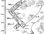
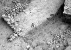
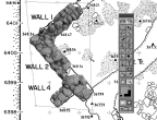
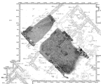
For this summary, we will focus on a corner wall group in trench EU7 at Tsoungiza (Fig. 1). To begin, it is important to select photographs of the area that have the most top detail visible. The photograph we chose (Fig. 2) has more downward detail than any other photo given to us by the excavators, and it just happens to have been taken with north straight up, matching the trench plan orientation. We have found that it saves a lot of trouble if several features at a time can be undistorted. Not all of the walls in this group are from the same period but we can work them together for now and put them into separate layers by phase later.
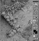
We create a path around the wall group so it can be copied and pasted onto the plan (Fig 3). For this step it is important to think about how the wall would be seen if looking straight down on it. That is, we need to concentrate on drawing around the top edges of rocks. For the most part, the sides of the wall are ignored since they would not be visible from above (that is, in plan view). Stones that protrude beyond the far edges would stick out sideways when pasted into the plan; so, unless they stick out sideways when viewed from above, these stones are cut short.
The pasted clipping often does not fit the plan drawing because of perspective distortion. The photograph was taken at an angle, so the parts of the wall that are farther away from the camera are smaller and closer together. For this reason we use a Photoshop tool to undistort the image to fit the plan (Fig. 4).
After a bit of work, we arrive at a pretty close match. If there are still some small discrepancies, we position them by trimming and distorting just those areas. Sometimes we need to "paint in" rocks that could not be seen because they were on the far side of the wall opposite the camera when the photograph was taken, but should appear in a plan view. We use photographs taken from other directions to detect and correct such details.
After placing all of the walls for a period onto the plan in this manner, we normally find that their colors just do not match each other and the image has a blaring collage-look about it. This is because the various photographs we used were taken at different times of day or when conditions in the trench were different. The choice of which photograph of a wall will serve as the coloration norm is usually done in consultation with a member of the field team who knows the area. (As closely as possible, our screens are color calibrated, and the photographs we get and scan are corrected using Munsell or Pantone color tables.) The rest of the images are then color corrected to match it. Chances are not all the photographs will match exactly but it’s worth the effort to reduce the collage-look to any degree. Color correcting is not a quick skill to learn nor is it something that can be done automatically with the software. It takes a solid understanding of additive color mixing (the way colors of light mix as opposed to paint) and lots of practice and patience.
To create areas of dirt or floor levels a few different techniques were used. In places where we had good photographs of the areas in question, we used the same clipping and warping method we used for the walls.
This entire process just described then repeats until one period plan is complete (Fig. 5), and then repeats again for other phases of the trench. The results produce an accurate and wonderfully graphic method of illustrating the chronological changes of an excavated area. (The results are probably best appreciated in color, so we invite you to visit our Web site, http://www.learningsites.com, navigate to the NVAP/ Tsoungiza directory and view the phase plans there.)
Once the technique of overlaying excavation photographs onto state plans is used for an entire series of period plans, researchers will be able to obtain a much clearer impression of the changes over time. Learning Sites then takes the finished set of period plans one step further, creating hyperlinks between the pieces of photographs we used to make up the walls, floors, and features with either the complete original photographs, or with 3D models of the trench, or with 3D models showing the architectural elements as we have reconstructed them.
To summarize the process, we:
Geoffrey Kornfeld &
Donald H. Sanders
Learning Sites, Inc.
(1) Sanders, Donald H. "Perceptions of the Pointed Arch: representations of Gothic architecture
from Villard to video disk," paper delivered at the Symposium in Honor of Stephen Gardner, New York City. May, 1991.
-----. "Architecture: The Neglected Artifact," pp.489-498 in E. B. French and K. A. Wardle, eds.,
Problems in Prehistory, Bristol Classical Press, Bristol, England. 1988.
Return to body.
(2) The author wishes to thank Project Director, Professor James C. Wright, Dean, Graduate School of Arts and Sciences, Bryn Mawr College, and Museum Director, Dr. Mary K. Dabney, Research Associate Department of Classical and Near Eastern Archaeology, Bryn Mawr College, and Director, Germantown Historical Society, Philadelphia, for permission to use their data for this exercise prior to its full release. As such, the excavation data presented here are for demonstration purposes only and are not meant in any way as an interim or final publication of the evidence. Return to body.
(3) Wright, James C. and Mary K. Dabney, eds. The Prehistoric Settlements on Tsoungiza at Ancient Nemea, American School of Classical Studies at Athens, forthcoming 2000. Return to body.
For other Newsletter articles concerning electronic publishing or the use of electronic media in the humanities, consult the Subject index.
Next Article: Using CAD on an Archaeological Site
Table of Contents for the Fall, 1999 issue of the CSA Newsletter (Vol. XII, no. 2)
 Table of Contents for all CSA Newsletter issues on the Web